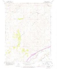
1978 Map of Hunter
USGS Topo · Published 1978About this map
The Humboldt River corridor dominates the southern edge of this Elko County landscape, serving as the primary artery for both water and transport. Two major railroads, the Southern Pacific and Western Pacific, flank the river as they traverse the valley floor near Hunter. This settlement pattern reflects the critical role of the river valley in bridging the high desert terrain. To the north, the Adobe Range rises sharply, characterized by a complex network of seasonal drainages including Susie Creek and Dry Susie Creek. Numerous springs, such as Upper Dry Susie Spring, provided essential water sources in an otherwise arid environment. Evidence of local infrastructure and aviation history appears through the presence of an Airway Beacon and a series of Jeep Trails that penetrate the upland reaches of the range.
Find a feature on this map
29 named features on this map. Tap any name to fly to it.
Don’t see what you’re looking for? This feature index may not catch every label — zoom into the map to look around manually.
Map Details
Editions of this 1978 Hunter Map
This is the sole edition of this map. No revisions or reprints were ever made.
Other maps of this area

1952 · Dixie Flats
USGS Topo · 1:62,500

1952 · Carlin
USGS Topo · 1:62,500

1955 · Winnemucca
USGS Topo · 1:250,000

1955 · Elko
USGS Topo · 1:250,000

1957 · Elko West
USGS Topo · 1:24,000

1958 · Winnemucca
USGS Topo · 1:250,000

1958 · Elko
USGS Topo · 1:250,000

1958 · Hunter
USGS Topo · 1:24,000

1958 · Huntsman Ranch
USGS Topo · 1:24,000

1958 · Doby Summit
USGS Topo · 1:24,000