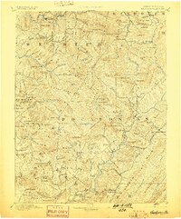
1894 Map of Huntersville
USGS Topo · Published 1898About this map
Addison and the high Allegheny peaks define this late 19th-century reconnaissance of the Pocahontas region. The landscape is characterized by a dense network of knobs and ridges, including Mingo Knob, Spruce Knob, and Red Oak Knob, which dictate the winding paths of the Williams River and Gauley River. Local education and early community life are anchored at Hillsboro Academy and the village of Hillsboro, while the presence of Cranberry Glades and Cherry Glades indicates the unique high-altitude wetlands of the plateau.
Find a feature on this map
130 named features on this map. Tap any name to fly to it.
Don’t see what you’re looking for? This feature index may not catch every label — zoom into the map to look around manually.
Map Details
Editions of this 1894 Huntersville Map
5 editions found

Other maps of this area

1887 · Hinton
USGS Topo · 1:125,000

1887 · Lewisburg
USGS Topo · 1:125,000

1889 · Nicholas
USGS Topo · 1:125,000

1889 · Beverly
USGS Topo · 1:125,000

1891 · Lewisburg
USGS Topo · 1:125,000

1891 · Nicholas
USGS Topo · 1:125,000

1891 · Huntersville
USGS Topo · 1:125,000

1892 · Beverly
USGS Topo · 1:125,000

1892 · Hinton
USGS Topo · 1:125,000

1893 · Buckhannon
USGS Topo · 1:125,000
Featured Places
- Marlinton, WV
- Addison (Webster Springs), WV
- Webster Springs, Addison (Webster Springs)
- Hillsboro, WV
- Upper Mingo, WV