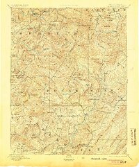
1894 Map of Huntersville
USGS Topo · Published 1905About this map
Huntersville and the Greenbrier River define this 1894 reconnaissance of the Allegheny Mountains, showing the area during a period of transition before large-scale commercial logging reshaped the drainage basins. The map documents the early development of Marlinton and Addison, alongside established rural centers like Mill Point and the Hillsboro Academy. The landscape is dominated by high ridges and gaps, with labels for family-named landmarks like Hunter Place and Bradshaw Hill that provide significant value for genealogists. The network of mountain forks, including Slaty Fork and Big Spring Fork, illustrates the original path of travel and settlement before modern road systems, while Gwin Flats and Slaty Ridge highlight the distinctive high-altitude topography of West Virginia's interior.
Find a feature on this map
159 named features on this map. Tap any name to fly to it.
Don’t see what you’re looking for? This feature index may not catch every label — zoom into the map to look around manually.
Map Details
Editions of this 1894 Huntersville Map
5 editions found

Other maps of this area

1887 · Hinton
USGS Topo · 1:125,000

1887 · Lewisburg
USGS Topo · 1:125,000

1889 · Nicholas
USGS Topo · 1:125,000

1889 · Beverly
USGS Topo · 1:125,000

1891 · Lewisburg
USGS Topo · 1:125,000

1891 · Nicholas
USGS Topo · 1:125,000

1891 · Huntersville
USGS Topo · 1:125,000

1892 · Beverly
USGS Topo · 1:125,000

1892 · Hinton
USGS Topo · 1:125,000

1893 · Buckhannon
USGS Topo · 1:125,000
Featured Places
- Marlinton, WV
- Addison (Webster Springs), WV
- Webster Springs, Addison (Webster Springs)
- Hillsboro, WV
- Upper Mingo, WV