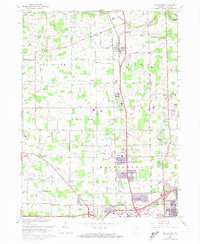
1963 Map of Huntertown
USGS Topo · Published 1974About this map
The Penn Central rail corridor and a distinct Treaty Boundary anchor this northern Indiana landscape as the suburban fringes of Fort Wayne began their northward expansion. The northern reaches are defined by a complex drainage network including Willow Creek, Eel River, and dozens of agricultural channels like Hatch Ditch and Geller Ditch. Small communities such as Huntertown and Wallen maintain their identities amidst a growing collection of institutional landmarks like the Byron Sanatorium, County Home, and the Smith Field airport. For genealogists, the map preserves the exact locations of several local burial grounds, including Fairview Cem and St Pauls Cem, along with community anchors like Bethel Ch and St Johns Ch. The 1972 revisions highlighted in purple show the rapid residential development pushing into areas once dominated by the Dunn Mill and family-named roads like Gump Road.
Find a feature on this map
85 named features on this map. Tap any name to fly to it.
Don’t see what you’re looking for? This feature index may not catch every label — zoom into the map to look around manually.
Map Details
Editions of this 1963 Huntertown Map
Other maps of this area

1953 · Fort Wayne
USGS Topo · 1:250,000

1955 · Ege
USGS Topo · 1:24,000

1956 · Fort Wayne
USGS Topo · 1:250,000

1956 · Fort Wayne West
USGS Topo · 1:24,000

1956 · Fort Wayne East
USGS Topo · 1:24,000

1956 · Cedarville
USGS Topo · 1:24,000

1957 · Auburn
USGS Topo · 1:24,000

1957 · Huntertown
USGS Topo · 1:24,000

1957 · Garrett
USGS Topo · 1:24,000

1957 · Churubusco
USGS Topo · 1:24,000