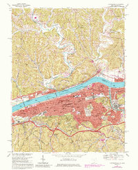
1968 Map of Huntington
USGS Topo · Published 1985About this map
Huntington thrives as a major river and rail hub along the Ohio River in this detailed study of the late 1960s. The dense urban grid of West Huntington and the city center transitions into the residential hills of Beverly Hills and Harveytown, while industrial and transit corridors are defined by the Baltimore and Ohio and Chesapeake and Ohio railroads. Across the river in Ohio, the smaller settlements of Chesapeake and Proctorville sit at the base of steep terrain marked by numerous gas wells and small rural chapels like Union Chapel. Significant civic landmarks include the Cabell County Courthouse, Huntington State Hospital, and Marshall University, reflecting the city's role as a regional center for governance and education. Local genealogy is supported by the clear mapping of Spring Hill Cemetery and dozens of neighborhood institutions, from St Josephs Sch to the Huntington Downtown Airport.
Find a feature on this map
83 named features on this map. Tap any name to fly to it.
Don’t see what you’re looking for? This feature index may not catch every label — zoom into the map to look around manually.
Map Details
Editions of this 1968 Huntington Map
4 editions found
Other maps of this area

1892 · Huntington
USGS Topo · 1:125,000

1898 · Huntington
USGS Topo · 1:125,000

1898 · Ironton
USGS Topo · 1:62,500

1900 · Ironton
USGS Topo · 1:62,500

1901 · Guyandot
USGS Topo · 1:62,500

1901 · Ceredo
USGS Topo · 1:62,500

1902 · Guyandot
USGS Topo · 1:62,500

1903 · Kenova
USGS Topo · 1:125,000

1904 · Kenova
USGS Topo · 1:125,000

1906 · Athalia
USGS Topo · 1:62,500