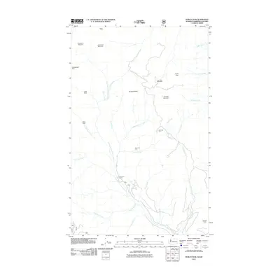
2011 Map of Hurley Peak
USGS Topo · Published 2011About this map
Johnny Bell Cabin and Border Camp anchor this 2011 survey of the high country straddling the international boundary. The landscape is defined by its complex drainage network, where North Fork Toats Coulee Creek and its many tributaries, including Corduroy Creek and Disappointment Creek, carve through the mountainous terrain. High peaks like Snowshoe Mountain, Hurley Peak, and Chopaka Mountain dominate the horizon, creating a network of ridges and draws such as Long Draw and Hells Hole. The presence of Cold Creek Camp and the Fourteen Mile Trailhead suggests a region utilized primarily for backcountry access and forest management. This map illustrates the intersection of named mountain summits—including Joe Mills Mountain and Goodenough Peak—with the seasonal water sources and meadows that sustain the local ecosystem, such as Snowshoe Meadow.
Find a feature on this map
32 named features on this map. Tap any name to fly to it.
Don’t see what you’re looking for? This feature index may not catch every label — zoom into the map to look around manually.
Map Details
Editions of this 2011 Hurley Peak Map
This is the sole edition of this map. No revisions or reprints were ever made.
Other maps of this area

1906 · Chopaka
USGS Topo · 1:125,000

1954 · Okanogan
USGS Topo · 1:250,000

1956 · Loomis
USGS Topo · 1:62,500

1956 · Horseshoe Basin
USGS Topo · 1:62,500

1958 · Okanogan
USGS Topo · 1:250,000
1981 · Corral Butte
USGS Topo · 1:24,000
1981 · Horseshoe Basin
USGS Topo · 1:24,000
1981 · Hurley Peak
USGS Topo · 1:24,000
1981 · Nighthawk
USGS Topo · 1:24,000
1981 · Duncan Ridge
USGS Topo · 1:24,000