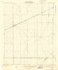
1937 Map of Huron
USGS Topo · Published 1937About this map
The small central California settlement of Huron serves as the focal point of this 1930s survey, situated at the intersection of Lassen Avenue and the Southern Pacific railroad line. The landscape reflects the grid-based development typical of the San Joaquin Valley, with long arterial roads like Siskiyou Avenue and Bishop Avenue dividing the valley floor into large agricultural or undeveloped sections. To the west, the terrain transitions toward the Guijarral Hills, while Canoas Creek appears in the southwestern corner. Along the southern edge of the sheet, Jayne Avenue marks a long, straight boundary through the arid expanse, highlighting the importance of road and rail infrastructure for these isolated agricultural hubs before mid-century expansion.
Find a feature on this map
10 named features on this map. Tap any name to fly to it.
Don’t see what you’re looking for? This feature index may not catch every label — zoom into the map to look around manually.
Map Details
Editions of this 1937 Huron Map
3 editions found
Other maps of this area

1912 · Coalinga
USGS Topo · 1:125,000

1926 · Lethent
USGS Topo · 1:31,680

1928 · Delta Farms No 3
USGS Topo · 1:31,680

1929 · Westhaven
USGS Topo · 1:31,680

1930 · Discovery Well
USGS Topo · 1:31,680

1930 · Canoas Creek
USGS Topo · 1:31,680

1932 · Delta Farms
USGS Topo · 1:31,680

1932 · West of Lethent
USGS Topo · 1:31,680

1933 · Kettleman City
USGS Topo · 1:31,680

1933 · Huron
USGS Topo · 1:31,680