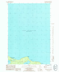
1985 Map of Huron Mountain
USGS Topo · Published 1985About this map
The southern shoreline of Lake Superior dominates this mid-1980s provisional study, showing the transition from the Great Lake into the interior waterways of Marquette County. The landscape is characterized by the prominent elevation of Huron Mountain, which overlooks the winding course of the Pine River. This waterway connects the open lake to Pine Lake, while further east, the terrain protects Conway Lake behind the sheltered waters of Conway Bay. Minimal infrastructure is present on the coast, though a Boat Dock and a Footbridge indicate localized access points near the river mouth. The map provides a clear look at the natural geography of Powell township before further modern development, focusing on the points and bays such as Pine River Point and Conway Point that define this stretch of Michigan's Upper Peninsula coast.
Find a feature on this map
13 named features on this map. Tap any name to fly to it.
Don’t see what you’re looking for? This feature index may not catch every label — zoom into the map to look around manually.
Map Details
Editions of this 1985 Huron Mountain Map
This is the sole edition of this map. No revisions or reprints were ever made.
Other maps of this area

1954 · Huron Mountain
USGS Topo · 1:62,500

1954 · Big Bay
USGS Topo · 1:62,500

1958 · Hancock
USGS Topo · 1:250,000

1958 · Marquette
USGS Topo · 1:250,000

1960 · Hancock
USGS Topo · 1:250,000

1960 · Marquette
USGS Topo · 1:250,000

1961 · Marquette
USGS Topo · 1:250,000

1961 · Hancock
USGS Topo · 1:250,000

1966 · Hancock
USGS Topo · 1:250,000

1968 · Marquette
USGS Topo · 1:250,000