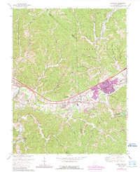
1972 Map of Hurricane
USGS Topo · Published 1989About this map
Teays Valley serves as the primary corridor for development and transport between the towns of Milton and Hurricane on this 1970s topographic record. The landscape is defined by the heavy infrastructure of Interstate 64 and the Chesapeake and Ohio railroad, which cut through the hills of Grant and Teays districts. While urban expansion is visible in purple around the major settlements, the surrounding ridges maintain a rural character, dotted with local landmarks like Redford Chapel, Signal Knob, and the Mill Creek Public Hunting Area. Genealogists and historians can trace the distribution of numerous small cemeteries and country churches such as Providence Ch and Bethany Ch. South of the valley, a network of hollows like Wolfpen Hollow and Hudson Hollow feed into the Mud River, illustrating the rugged drainage patterns of the Culloden area.
Find a feature on this map
47 named features on this map. Tap any name to fly to it.
Don’t see what you’re looking for? This feature index may not catch every label — zoom into the map to look around manually.
Map Details
Editions of this 1972 Hurricane Map
2 editions found
Other maps of this area

1892 · Huntington
USGS Topo · 1:125,000

1898 · Huntington
USGS Topo · 1:125,000

1899 · Charleston
USGS Topo · 1:125,000

1902 · Milton
USGS Topo · 1:62,500

1906 · Glenwood
USGS Topo · 1:62,500

1906 · Winfield
USGS Topo · 1:62,500

1908 · Glenwood
USGS Topo · 1:62,500

1908 · Winfield
USGS Topo · 1:62,500

1909 · Saint Albans
USGS Topo · 1:62,500

1931 · Saint Albans
USGS Topo · 1:62,500