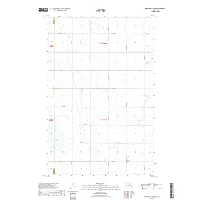
2017 Map of Hurricane Lake East
USGS Topo · Published 2017About this map
Hurricane Lake dominates the southwestern corner of this survey, defining a landscape of prairie wetlands and seasonal basins at the border of Pierce Co and Towner Co. The map records a sparsely populated agricultural region structured by a rigid section-line road grid, including 67th St NE and 58th Ave NE. Local history is preserved in small rural burial grounds like Wahl Cem and Ostreim Cem, located near the intersection of the county line and the 157th township boundary. This 2017 edition by the U.S. Geological Survey shows the modern evolution of the Red River Valley’s western fringes, where traditional land divisions remain the primary markers of human presence across the open plains.
Find a feature on this map
21 named features on this map. Tap any name to fly to it.
Don’t see what you’re looking for? This feature index may not catch every label — zoom into the map to look around manually.
Map Details
Editions of this 2017 Hurricane Lake East Map
This is the sole edition of this map. No revisions or reprints were ever made.
Other maps of this area

1953 · Devils Lake
USGS Topo · 1:250,000

1956 · Devils Lake
USGS Topo · 1:250,000

1971 · Bisbee South
USGS Topo · 1:24,000

1971 · Considine
USGS Topo · 1:24,000

1971 · Leeds NE
USGS Topo · 1:24,000

1971 · Hurricane Lake West
USGS Topo · 1:24,000

1971 · York
USGS Topo · 1:24,000

1971 · Leeds
USGS Topo · 1:24,000

1971 · Mylo SE
USGS Topo · 1:24,000
1971 · Hurricane Lake East
USGS Topo · 1:24,000