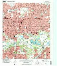
1995 Map of Hurst
USGS Topo · Published 2001About this map
The West Fork Trinity River winds through the heart of this landscape, separating the densely developed residential grids of Hurst and Bedford from the industrial and recreational zones to the south. In the mid-1990s, the area reflects a mature suburban environment, where legacy landmarks like the Harrison Cem and Parker Cem remain preserved amidst modern civic growth. The presence of a Former Gravel Pit and expansive gaging stations along the river corridors points to the ongoing management of the Trinity watershed, while the small settlement of Ederville sits near the busy interchange at the southern edge of the quadrangle. Local community life is anchored by institutions such as St Philip Ch and schools like Richland Jr High Sch, providing a detailed look at the social and physical infrastructure of the Mid-Cities region during this period of Texas expansion.
Find a feature on this map
66 named features on this map. Tap any name to fly to it.
Don’t see what you’re looking for? This feature index may not catch every label — zoom into the map to look around manually.
Map Details
Editions of this 1995 Hurst Map
This is the sole edition of this map. No revisions or reprints were ever made.
Other maps of this area

1894 · Fort Worth
USGS Topo · 1:125,000

1931 · Grapevine
USGS Topo · 1:62,500

1954 · Dallas
USGS Topo · 1:250,000

1955 · Haltom City
USGS Topo · 1:24,000

1955 · Keller
USGS Topo · 1:24,000

1955 · Fort Worth
USGS Topo · 1:24,000

1955 · Haltom City
USGS Topo · 1:62,500

1958 · Dallas
USGS Topo · 1:250,000

1959 · Kennedale
USGS Topo · 1:24,000

1959 · Arlington
USGS Topo · 1:24,000