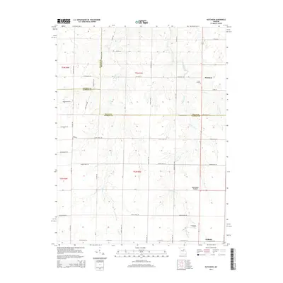
2015 Map of Hutchison
USGS Topo · Published 2015About this map
Laddonia serves as the primary hub in the southeastern corner of this landscape, where the confluence of several rural county roads meets the rail lines. The terrain is defined by the branching network of the Lick Creek system, including West Lick Creek, Middle Lick Creek, and East Lick Creek, which carve gentle drainage patterns across the Audrain and Ralls county lines. Small rural clusters like Hutchison and Bassinger Corner mark the intersections of the local grid, while legacy landmarks such as Corinth Cemetery and Unity Cemetery provide important points of reference for local family history. This 2015 update from the U.S. Geological Survey also documents transportation and utility features like the Schlemmer Airport, showing the modern infrastructure overlaid on the traditional agricultural township system of t53n r7w and surrounding sections.
Find a feature on this map
35 named features on this map. Tap any name to fly to it.
Don’t see what you’re looking for? This feature index may not catch every label — zoom into the map to look around manually.
Map Details
Editions of this 2015 Hutchison Map
This is the sole edition of this map. No revisions or reprints were ever made.
Other maps of this area

1890 · Mexico
USGS Topo · 1:125,000

1932 · Mexico
USGS Topo · 1:62,500

1942 · Wellsville
USGS Topo · 1:62,500

1945 · Florida
USGS Topo · 1:62,500

1945 · Perry
USGS Topo · 1:62,500

1948 · Quincy
USGS Topo · 1:250,000

1956 · Quincy
USGS Topo · 1:250,000
1972 · Mexico East
USGS Topo · 1:24,000
1972 · Santa Fe
USGS Topo · 1:24,000
1972 · Florida
USGS Topo · 1:24,000