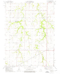
1973 Map of Hutchison
USGS Topo · Published 1975About this map
The rolling agricultural landscape of northern Audrain County is defined by the convergence of several waterways into the Salt River. This 1970s landscape shows a transition from the southern Prairie terrain to the more dissected drainage basins of West Lick Creek, Middle Lick Creek, and East Lick Creek. Small rural communities and landmarks anchor the region, including the settlement of Hutchison and the junction at Bassinger Corner. Genealogy and local history researchers will find important community nodes such as Prairie View Ch and nearby Corinth Cem. The map also captures the political geography of the era, where the borders of Monroe, Ralls, and Audrain counties meet amidst a network of secondary roads and bridge crossings.
Find a feature on this map
18 named features on this map. Tap any name to fly to it.
Don’t see what you’re looking for? This feature index may not catch every label — zoom into the map to look around manually.
Map Details
Editions of this 1973 Hutchison Map
This is the sole edition of this map. No revisions or reprints were ever made.
Other maps of this area

1890 · Mexico
USGS Topo · 1:125,000

1932 · Mexico
USGS Topo · 1:62,500

1942 · Wellsville
USGS Topo · 1:62,500

1945 · Florida
USGS Topo · 1:62,500

1945 · Perry
USGS Topo · 1:62,500

1948 · Quincy
USGS Topo · 1:250,000

1956 · Quincy
USGS Topo · 1:250,000
1972 · Mexico East
USGS Topo · 1:24,000
1972 · Santa Fe
USGS Topo · 1:24,000
1972 · Florida
USGS Topo · 1:24,000