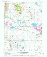
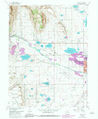
1968 Map of Hygiene
USGS Topo · Published 1980About this map
Hygiene serves as a central point in this late-1960s landscape, illustrating a complex network of agricultural water management north of Longmont. The map documents an intricate system of reservoirs and ditches, including Mc Intosh Lake, Clover Basin Reservoir, and Lagerman Reservoir, which supported the region's farming economy. The transition from the high plains to the foothills is marked by Rabbit Mountain and Indian Mountain in the west, while the expanding footprint of Longmont reaches toward Marnett and Dominion. Notable infrastructure of the era is evident in the Longmont Municipal Airport and the specialized Antenna Field Sites near Table Mountain. Genealogists and local historians can locate specific landmarks such as Rymby Ch and various filtration plants that supported the growing population center along St Vrain Creek.
Find a feature on this map
42 named features on this map. Tap any name to fly to it.
Don’t see what you’re looking for? This feature index may not catch every label — zoom into the map to look around manually.
Map Details
Editions of this 1968 Hygiene Map
5 editions found
Other maps of this area

1902 · Boulder
USGS Topo · 1:62,500

1904 · Niwot
USGS Topo · 1:62,500

1904 · Boulder
USGS Topo · 1:62,500

1905 · Mount Olympus
USGS Topo · 1:62,500

1906 · Loveland
USGS Topo · 1:62,500

1907 · Mount Olympus
USGS Topo · 1:62,500

1908 · Loveland
USGS Topo · 1:62,500

1950 · Hygiene
USGS Topo · 1:24,000
1950 · Erie
USGS Topo · 1:24,000

1950 · Niwot
USGS Topo · 1:24,000