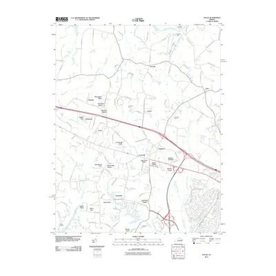
2010 Map of Hylas
USGS Topo · Published 2010About this map
Rockville and Centerville anchor this part of Hanover County during a period of suburban expansion north of Richmond. The landscape is defined by the drainage of the South Anna River in the north and the sprawling network of Tuckahoe Creek to the south. Numerous small residential developments, such as Hermitage Hamlet, Nelwood Estates, and Woods Acres, illustrate the transition from traditional rural farmland to contemporary residential communities. Water management is evident through several named structures like Cochran Dam and Broad Branch Dam, which regulate local waterways. Aviation history is represented by the Rockville Airport and Sabot Airport, while the legacy of established families and settlements persists through names like Johnsons Springs and Few Acres Farm. This record of the early 21st century highlights a region balancing its agricultural roots with the increasing demands of regional growth and infrastructure.
Find a feature on this map
101 named features on this map. Tap any name to fly to it.
Don’t see what you’re looking for? This feature index may not catch every label — zoom into the map to look around manually.
Map Details
Editions of this 2010 Hylas Map
This is the sole edition of this map. No revisions or reprints were ever made.
Other maps of this area

1890 · Goochland
USGS Topo · 1:125,000

1892 · Goochland
USGS Topo · 1:125,000

1936 · Richmond West
USGS Topo · 1:24,000

1936 · Glen Allen
USGS Topo · 1:24,000

1941 · Glen Allen
USGS Topo · 1:31,680

1942 · Westhampton
USGS Topo · 1:31,680

1943 · Mabelton
USGS Topo · 1:31,680

1943 · Fine Creek Mills
USGS Topo · 1:31,680
1943 · Hanover Academy
USGS Topo · 1:31,680

1943 · Perkinsville
USGS Topo · 1:31,680