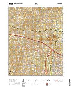
2019 Map of Hylas
USGS Topo · Published 2019About this map
Rockville and the neighboring community of Hylas sit at the northern edge of this Piedmont landscape, where the South Anna River winds along the Goochland and Hanover county line. The map reveals a transition from the rolling woodlands and rural estates of the north to the suburbanizing corridors of Centerville and Hickory Haven in the south. Transportation patterns define the area, from the historic winding curves of Pouncey Tract Rd and Dogwood Trail Rd to the modern bypasses that now intersect the countryside.
Find a feature on this map
161 named features on this map. Tap any name to fly to it.
Don’t see what you’re looking for? This feature index may not catch every label — zoom into the map to look around manually.
Map Details
Editions of this 2019 Hylas Map
This is the sole edition of this map. No revisions or reprints were ever made.
Other maps of this area

1890 · Goochland
USGS Topo · 1:125,000

1892 · Goochland
USGS Topo · 1:125,000

1936 · Richmond West
USGS Topo · 1:24,000

1936 · Glen Allen
USGS Topo · 1:24,000

1941 · Glen Allen
USGS Topo · 1:31,680

1942 · Westhampton
USGS Topo · 1:31,680

1943 · Mabelton
USGS Topo · 1:31,680

1943 · Fine Creek Mills
USGS Topo · 1:31,680
1943 · Hanover Academy
USGS Topo · 1:31,680

1943 · Perkinsville
USGS Topo · 1:31,680