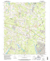
1994 Map of Hylas
USGS Topo · Published 1996About this map
Rockville and Hylas sit at the northern edge of this Piedmont landscape, which is defined by the convergence of the Hanover and Goochland county lines. The terrain is deeply incised by a dense network of waterways, including Shop Creek, Goldmine Creek, and Little Tuckahoe Creek, all feeding into the larger drainage systems of the South Anna River and Tuckahoe Creek. In the mid-1990s, this area reflects a rural character punctuated by established crossroads like Johnsons Spring and Centerville. Dozens of small family or community cemeteries, marked simply as Cem, are scattered across the ridges, providing a clear map for genealogists tracing ancestral landholdings. Industrial and modern infrastructure, such as a large Quarry near the eastern boundary and a Pipeline corridor crossing the southern reaches, indicate the ongoing development of the region's natural resources and utility networks.
Find a feature on this map
30 named features on this map. Tap any name to fly to it.
Don’t see what you’re looking for? This feature index may not catch every label — zoom into the map to look around manually.
Map Details
Editions of this 1994 Hylas Map
This is the sole edition of this map. No revisions or reprints were ever made.
Other maps of this area

1890 · Goochland
USGS Topo · 1:125,000

1892 · Goochland
USGS Topo · 1:125,000

1936 · Richmond West
USGS Topo · 1:24,000

1936 · Glen Allen
USGS Topo · 1:24,000

1941 · Glen Allen
USGS Topo · 1:31,680

1942 · Westhampton
USGS Topo · 1:31,680

1943 · Mabelton
USGS Topo · 1:31,680

1943 · Fine Creek Mills
USGS Topo · 1:31,680
1943 · Hanover Academy
USGS Topo · 1:31,680

1943 · Perkinsville
USGS Topo · 1:31,680