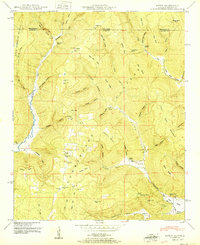
1951 Map of Hytop
USGS Topo · Published 1951About this map
The Cumberland Plateau landscape along the Alabama-Tennessee state line defines this area, where narrow hollows and steep ridges separate small upland communities. In the early post-war years, the settlement of Hytop and the nearby village of Jericho serve as the primary hubs for this rural part of Jackson County. The terrain is deeply carved by water, with Hurricane Creek and Big Coon Creek creating significant valleys through the plateau. Local life and history are anchored by small landmarks such as the Walnut Grove School and several family-named burial grounds including Hytop Cem, Knight Cem, and Matthews Cem. These features, along with names like Polly Anne Spring and Devers Cove, suggest a long-established pattern of high-country farming and family settlements before modern development altered the region.
Find a feature on this map
64 named features on this map. Tap any name to fly to it.
Don’t see what you’re looking for? This feature index may not catch every label — zoom into the map to look around manually.
Map Details
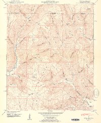
Editions of this 1951 Hytop Map
2 editions found
Other maps of this area

1886 · Stevenson
USGS Topo · 1:125,000

1888 · Scottsboro
USGS Topo · 1:125,000

1892 · Scottsboro
USGS Topo · 1:125,000

1892 · Stevenson
USGS Topo · 1:125,000

1895 · Stevenson
USGS Topo · 1:125,000

1895 · Sewanee
USGS Topo · 1:125,000

1928 · Decherd
USGS Topo · 1:62,500

1936 · Wannville
USGS Topo · 1:24,000
1936 · Sinking Cove
USGS Topo · 1:24,000
1936 · Beans Creek
USGS Topo · 1:24,000