
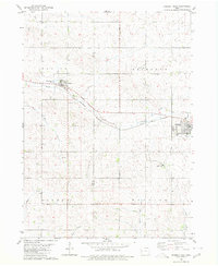
1967 Map of Ida Grove
USGS Topo · Published 1968About this map
Ida Grove serves as the focal point of this late-1960s Iowa landscape, situated at the confluence of the Maple River and Odebolt Creek. The town's layout reflects a typical mid-century Midwestern hub, with the Chicago and North Western railroad bisecting the community and providing a vital link for the agricultural economy. To the northwest, Moorehead Pioneer Park occupies a bend in the river, while the Sacred Heart Cem and Ida Grove Cemetery mark the community's established local history.
Find a feature on this map
20 named features on this map. Tap any name to fly to it.
Don’t see what you’re looking for? This feature index may not catch every label — zoom into the map to look around manually.
Map Details
Editions of this 1967 Ida Grove Map
This is the sole edition of this map. No revisions or reprints were ever made.
Other maps of this area

1954 · Fort Dodge
USGS Topo · 1:250,000

1957 · Fort Dodge
USGS Topo · 1:250,000

1958 · Fort Dodge
USGS Topo · 1:250,000

1967 · Holstein
USGS Topo · 1:24,000

1967 · Battle Creek
USGS Topo · 1:24,000

1967 · Ida Grove NW
USGS Topo · 1:24,000

1971 · Ricketts
USGS Topo · 1:24,000

1971 · Schleswig
USGS Topo · 1:24,000

1971 · Kiron
USGS Topo · 1:24,000
1980 · Odebolt West
USGS Topo · 1:24,000