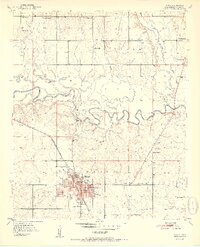
1951 Map of Idabel
USGS Topo · Published 1951About this map
The county seat of Idabel serves as the focal point of this 1950s survey, showing a well-developed civic infrastructure including the local Courthouse, an Armory, and a collection of neighborhood schools such as Gray High Sch, Washington Sch, and Herndon Sch. The town is situated at the intersection of the ST L-S F railroad and several regional roads, supporting its growth as a hub in the southeastern Oklahoma timber and agricultural country.
Find a feature on this map
42 named features on this map. Tap any name to fly to it.
Don’t see what you’re looking for? This feature index may not catch every label — zoom into the map to look around manually.
Map Details
Editions of this 1951 Idabel Map
2 editions found
Other maps of this area

1902 · Lukfata
USGS Topo · 1:125,000

1950 · Mcalester
USGS Topo · 1:250,000

1950 · Idabel
USGS Topo · 1:24,000

1950 · Acworth
USGS Topo · 1:24,000

1950 · Shults
USGS Topo · 1:24,000

1950 · Haworth
USGS Topo · 1:24,000

1951 · Idabel
USGS Topo · 1:24,000

1951 · Garvin
USGS Topo · 1:24,000

1951 · Idabel SE
USGS Topo · 1:24,000

1951 · Haworth
USGS Topo · 1:24,000