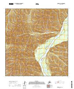
2019 Map of Iditarod B-1 NE
USGS Topo · Published 2019About this map
The Kuskokwim River flows through this remote interior Alaskan landscape, serving as the dominant geographical feature in a region defined by extensive public land divisions. This 2019 survey focuses on a largely unsettled area within the Yukon-Koyukuk Census Area, where the river's winding course creates a natural corridor through the surrounding wilderness. The map documents the precise township and range boundaries, including t27n r37w and t28n r37w, which are essential for understanding land management and surveying history in this part of the Alaska interior. The absence of roads or permanent settlements emphasizes the character of the terrain as it existed in the early twenty-first century, primarily accessible by the water or air.
Find a feature on this map
9 named features on this map. Tap any name to fly to it.
Don’t see what you’re looking for? This feature index may not catch every label — zoom into the map to look around manually.
Map Details
Editions of this 2019 Iditarod B-1 NE Map
This is the sole edition of this map. No revisions or reprints were ever made.
Other maps of this area

1949 · McGrath
USGS Topo · 1:250,000

1950 · McGrath
USGS Topo · 1:250,000

1951 · Iditarod
USGS Topo · 1:250,000

1954 · Iditarod B-1
USGS Topo · 1:63,360

1954 · McGrath B-6
USGS Topo · 1:63,360

1954 · McGrath C-6
USGS Topo · 1:63,360
1956 · Iditarod C-1
USGS Topo · 1:63,360

1956 · Iditarod
USGS Topo · 1:250,000

1958 · McGrath
USGS Topo · 1:250,000
2019 · McGrath B-6 SW
USGS Topo · 1:25,000