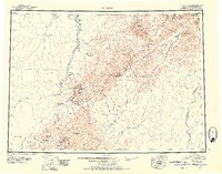
1951 Map of Iditarod
USGS Topo · Published 1952About this map
The Iditarod River winds through the heart of this mid-century topographic survey, documenting a region defined by its gold mining history and remote transportation routes. Centered on the historic mining camp of Iditarod, the map details the network of trails and watercourses that sustained the area, including the Winter Trail and Summer Trail. The settlement patterns around Flat and Discovery reflect the late-stage interior mining boom, where the landscape is marked by numerous Placer Mines and isolated Cabins. The terrain transitions from the river lowlands to the heights of the Kuskokwim Mountains and Beaver Mountains. Notable landmarks like Swinging Dome and De Courcy Mtn provide vertical context to the extensive creek systems, such as Otter Creek and Bonanza Creek, which were central to the local economy.
Find a feature on this map
86 named features on this map. Tap any name to fly to it.
Don’t see what you’re looking for? This feature index may not catch every label — zoom into the map to look around manually.
Map Details
Editions of this 1951 Iditarod Map
4 editions found

Other maps of this area

1947 · Russian Mission
USGS Topo · 1:250,000

1949 · McGrath
USGS Topo · 1:250,000

1950 · Medfra
USGS Topo · 1:250,000

1950 · Russian Mission
USGS Topo · 1:250,000

1950 · Sleetmute
USGS Topo · 1:250,000

1950 · McGrath
USGS Topo · 1:250,000

1951 · Ophir
USGS Topo · 1:250,000

1951 · Unalakleet
USGS Topo · 1:250,000

1951 · Holy Cross
USGS Topo · 1:250,000

1951 · Lime Hills
USGS Topo · 1:250,000