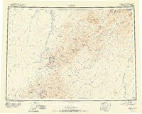
1951 Map of Iditarod
USGS Topo · Published 1956About this map
The Iditarod River snakes through this mid-century landscape, a region defined by the fading echoes of the gold rush era. In this 1951 survey, the settlement at Flat remains a focal point of activity, while surrounding towns like Iditarod, Otter, and Dikeman are already marked as abandoned. These sites, along with Discovery and numerous Placer Mines, trace the history of the Iditarod Mining District.
Find a feature on this map
122 named features on this map. Tap any name to fly to it.
Don’t see what you’re looking for? This feature index may not catch every label — zoom into the map to look around manually.
Map Details
Editions of this 1951 Iditarod Map
4 editions found

Other maps of this area

1947 · Russian Mission
USGS Topo · 1:250,000

1949 · McGrath
USGS Topo · 1:250,000

1950 · Medfra
USGS Topo · 1:250,000

1950 · Russian Mission
USGS Topo · 1:250,000

1950 · Sleetmute
USGS Topo · 1:250,000

1950 · McGrath
USGS Topo · 1:250,000

1951 · Ophir
USGS Topo · 1:250,000

1951 · Unalakleet
USGS Topo · 1:250,000

1951 · Holy Cross
USGS Topo · 1:250,000

1951 · Lime Hills
USGS Topo · 1:250,000