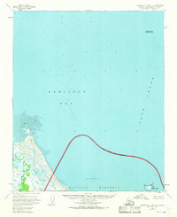
1951 Map of Iliamna A-1 and A-2
USGS Topo · Published 1968About this map
Katmai National Monument dominates the southwestern corner of this coastal Alaska survey, defined by its approximate National Monument Boundary. The landscape is a transition from the marshy outlets of the Douglas River to the open waters of Kamishak Bay and Cook Inlet. Hydrographic data compiled in the early 1950s highlights the treacherous maritime environment, featuring soundings that reveal underwater topography near Augustine Rocks and a vast Tidal Flat along the shoreline. This area remains largely undeveloped, focused on the natural boundary between the protected monument land and the sea, with Shaw Island marking a solitary landmass in the southeastern waters. The lack of roads or trails emphasizes the preservation of this remote wilderness area as it existed during the mid-century mapping effort.
Find a feature on this map
8 named features on this map. Tap any name to fly to it.
Don’t see what you’re looking for? This feature index may not catch every label — zoom into the map to look around manually.
Map Details
Editions of this 1951 Iliamna A-1 and A-2 Map
3 editions found
Other maps of this area

1951 · Iliamna A-3
USGS Topo · 1:63,360

1951 · Iliamna A-1 and A-2
USGS Topo · 1:63,360

1951 · Afognak D-5
USGS Topo · 1:63,360

1951 · Afognak D-6
USGS Topo · 1:63,360

1952 · Iliamna
USGS Topo · 1:250,000

1952 · Afognak
USGS Topo · 1:250,000

1954 · Iliamna B-3
USGS Topo · 1:63,360

1957 · Iliamna
USGS Topo · 1:250,000

1958 · Iliamna B-2
USGS Topo · 1:63,360
1983 · Afognak D-6
USGS Topo · 1:63,360