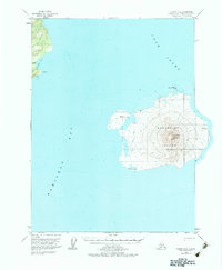
1958 Map of Iliamna B-2
USGS Topo · Published 1983About this map
Augustine Volcano dominates this mid-century topographic survey of the volcanic landscape within Cook Inlet. The map details the conical profile of Augustine Island, an active volcanic peak surrounded by the waters of Kamishak Bay. On the western shoreline of the island, a lone Cabin and a networked Tractor Trail suggest a modest human presence or seasonal activity in this otherwise geologically driven environment. Along the mainland coast to the northwest, landmarks like Rocky Cove and Tignagvik Pt define the rugged coastline. The inclusion of several vertical angle bench marks, such as VABM West Augustine and VABM Burr, indicates the precise surveying efforts required to chart this dynamic terrain during the late 1950s.
Find a feature on this map
15 named features on this map. Tap any name to fly to it.
Don’t see what you’re looking for? This feature index may not catch every label — zoom into the map to look around manually.
Map Details
Editions of this 1958 Iliamna B-2 Map
3 editions found
Other maps of this area

1949 · Iliamna C-1
USGS Topo · 1:63,360

1951 · Iliamna A-3
USGS Topo · 1:63,360

1951 · Iliamna A-1 and A-2
USGS Topo · 1:63,360

1952 · Iliamna
USGS Topo · 1:250,000

1954 · Iliamna C-3
USGS Topo · 1:63,360

1954 · Iliamna B-3
USGS Topo · 1:63,360

1957 · Iliamna
USGS Topo · 1:250,000

1958 · Iliamna C-2
USGS Topo · 1:63,360

1958 · Iliamna B-2
USGS Topo · 1:63,360

1958 · Iliamna C-1
USGS Topo · 1:63,360