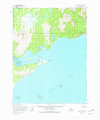
1954 Map of Iliamna B-3
USGS Topo · Published 1977About this map
Bruin Bay and the wide expanse of Kamishak Bay define this stretch of the Kenai Peninsula Borough coast. The map illustrates a dramatic meeting of land and sea, where the inland Kakhonak Lake sits amidst high terrain near the northern edge of the survey. Moving toward the shoreline, the topography shifts from the elevated heights of Big Hill and Step Mountain to the steep drops of Fortification Bluff. Hydrographic details include Sunday Creek and the notable Falls that drain from Kirschner Lake toward the sea. The coastal boundary is marked by distinct features such as Contact Point and various Tidal Flats, reflecting the tidally influenced landscape of the mid-twentieth century before further coastal development or environmental changes took place.
Find a feature on this map
13 named features on this map. Tap any name to fly to it.
Don’t see what you’re looking for? This feature index may not catch every label — zoom into the map to look around manually.
Map Details
Editions of this 1954 Iliamna B-3 Map
3 editions found
Other maps of this area

1951 · Iliamna A-4
USGS Topo · 1:63,360

1951 · Iliamna A-3
USGS Topo · 1:63,360

1951 · Iliamna A-1 and A-2
USGS Topo · 1:63,360

1952 · Iliamna
USGS Topo · 1:250,000

1952 · Iliamna A-4
USGS Topo · 1:63,360

1954 · Iliamna C-3
USGS Topo · 1:63,360

1954 · Iliamna B-3
USGS Topo · 1:63,360

1954 · Iliamna C-4
USGS Topo · 1:63,360

1954 · Iliamna B-4
USGS Topo · 1:63,360

1957 · Iliamna
USGS Topo · 1:250,000