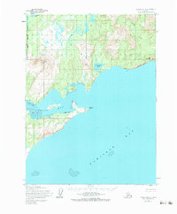
1954 Map of Iliamna B-3
USGS Topo · Published 1983About this map
Kamishak Bay and the coastal reaches of the Kenai Peninsula Borough define this mid-century topographic survey, where the rugged shoreline of Bruin Bay meets the waters of Cook Inlet. The landscape is dominated by coastal elevations like Big Hill and the prominent Step Mountain, which rises above Fortification Bluff. Inland, the drainage pattern is anchored by Kirschner Lake and its associated Falls, while the northern portion of the sheet captures a section of Kakhonak Lake. This map represents the area as it was recorded during aerial photography in the late 1950s, showing a wilderness terrain completely devoid of roads or trails. The intricate shoreline features significant Tidal Flats and sharp geographical markers such as Contact Point, providing a detailed look at the maritime geography before modern development or environmental shifts altered these remote Alaskan reaches.
Find a feature on this map
13 named features on this map. Tap any name to fly to it.
Don’t see what you’re looking for? This feature index may not catch every label — zoom into the map to look around manually.
Map Details
Editions of this 1954 Iliamna B-3 Map
3 editions found
Other maps of this area

1951 · Iliamna A-4
USGS Topo · 1:63,360

1951 · Iliamna A-3
USGS Topo · 1:63,360

1951 · Iliamna A-1 and A-2
USGS Topo · 1:63,360

1952 · Iliamna
USGS Topo · 1:250,000

1952 · Iliamna A-4
USGS Topo · 1:63,360

1954 · Iliamna C-3
USGS Topo · 1:63,360

1954 · Iliamna B-3
USGS Topo · 1:63,360

1954 · Iliamna C-4
USGS Topo · 1:63,360

1954 · Iliamna B-4
USGS Topo · 1:63,360

1957 · Iliamna
USGS Topo · 1:250,000