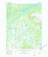
1954 Map of Iliamna B-4
USGS Topo · Published 1981About this map
Kakhonak Lake dominates the northern reaches of this coastal Alaskan landscape, its waters feeding into the Kakhonak River as it flows toward Kakhonak Bay. The terrain transitions from the marshy lowlands surrounding Venturi Lake to the prominent peaks of the Seven Sisters in the northeast. This 1950s-era survey, revised in the mid-1970s, documents a remote wilderness within the Kenai Peninsula Borough where human presence is sparse. Researchers will find the Amakdedori (Site) near the mouth of Amakdedori Creek on the shores of Kamishak Bay, marking an area of historical significance. Other signs of activity are limited to a lone Cabin and the wide expanse of the Bruin Bay Tidal Flat, illustrating the intersection of freshwater drainage systems like Dunnulak Creek with the saltwater inlets of Sid Larson Bay.
Find a feature on this map
13 named features on this map. Tap any name to fly to it.
Don’t see what you’re looking for? This feature index may not catch every label — zoom into the map to look around manually.
Map Details
Editions of this 1954 Iliamna B-4 Map
4 editions found

Other maps of this area

1951 · Iliamna A-5
USGS Topo · 1:63,360

1951 · Iliamna A-4
USGS Topo · 1:63,360

1951 · Iliamna B-5
USGS Topo · 1:63,360

1951 · Iliamna A-3
USGS Topo · 1:63,360

1952 · Iliamna
USGS Topo · 1:250,000

1952 · Iliamna A-4
USGS Topo · 1:63,360

1952 · Iliamna A-5
USGS Topo · 1:63,360

1954 · Iliamna C-5
USGS Topo · 1:63,360

1954 · Iliamna C-3
USGS Topo · 1:63,360

1954 · Iliamna B-3
USGS Topo · 1:63,360