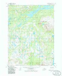
1954 Map of Iliamna B-4
USGS Topo · Published 1986About this map
Kakhonak Lake dominates the northern reaches of this coastal Alaskan landscape, its waters flowing via the Kakhonak River toward the intricate coastline of Kakhonak Bay and Sid Larson Bay. This mid-century survey captures a transition point between the interior lakes and the tidal flats of Kamishak Bay. In the southeast, the settlement of Amakdedori sits near the mouth of Amakdedori Creek, representing one of the few named habitation points in the region.
Find a feature on this map
13 named features on this map. Tap any name to fly to it.
Don’t see what you’re looking for? This feature index may not catch every label — zoom into the map to look around manually.
Map Details
Editions of this 1954 Iliamna B-4 Map
4 editions found

Other maps of this area

1951 · Iliamna A-5
USGS Topo · 1:63,360

1951 · Iliamna A-4
USGS Topo · 1:63,360

1951 · Iliamna B-5
USGS Topo · 1:63,360

1951 · Iliamna A-3
USGS Topo · 1:63,360

1952 · Iliamna
USGS Topo · 1:250,000

1952 · Iliamna A-4
USGS Topo · 1:63,360

1952 · Iliamna A-5
USGS Topo · 1:63,360

1954 · Iliamna C-5
USGS Topo · 1:63,360

1954 · Iliamna C-3
USGS Topo · 1:63,360

1954 · Iliamna B-3
USGS Topo · 1:63,360