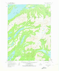
1954 Map of Iliamna C-3
USGS Topo · Published 1973About this map
Old Iliamna (Abandoned) stands as a silent sentinel on the banks of the Iliamna River in this mid-century survey of the northern Cook Inlet region. This remote wilderness is defined by its complex waterway network, connecting Pedro Bay and Pile Bay to the interior highlands of the Chitigum Mountains. Long-established movement through the terrain is marked by a Native Trail that cuts across the valley floors between Silver Creek and Ptarmigan Creek. The landscape transition is evident where the high peaks of The Cone overlook the tidal flats of Ursus Cove. Scattered cabins and a few small settlements like Pile suggest a subsistence economy tied to the land and the massive freshwater systems of Meadow Lake and Kakhonak Lake.
Find a feature on this map
23 named features on this map. Tap any name to fly to it.
Don’t see what you’re looking for? This feature index may not catch every label — zoom into the map to look around manually.
Map Details
Editions of this 1954 Iliamna C-3 Map
2 editions found
Other maps of this area

1952 · Iliamna
USGS Topo · 1:250,000

1954 · Iliamna D-3
USGS Topo · 1:63,360

1954 · Iliamna D-4
USGS Topo · 1:63,360

1954 · Iliamna C-3
USGS Topo · 1:63,360

1954 · Iliamna B-3
USGS Topo · 1:63,360

1954 · Iliamna C-4
USGS Topo · 1:63,360

1954 · Iliamna B-4
USGS Topo · 1:63,360

1957 · Iliamna
USGS Topo · 1:250,000

1958 · Iliamna D-2
USGS Topo · 1:63,360

1958 · Iliamna C-2
USGS Topo · 1:63,360