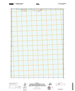
2019 Map of Iliamna C-7 SW
USGS Topo · Published 2019About this map
Iliamna Lake dominates this northern reach of the Alaska Peninsula, its vast waters filling the majority of the landscape. Along the northern shoreline, Lower Talarik Creek meanders toward the lake, marking a transition between the open water and the interior wilderness of the Lake and Peninsula Borough. The map is defined by the Public Land Survey System grid, which organizes the expansive terrain into townships and ranges such as t7s r37w and t6s r37w. This 2019 data reflects the remote and largely undeveloped character of the region, where natural hydrography and surveying coordinates provide the primary framework for navigation and land management.
Find a feature on this map
44 named features on this map. Tap any name to fly to it.
Don’t see what you’re looking for? This feature index may not catch every label — zoom into the map to look around manually.
Map Details
Editions of this 2019 Iliamna C-7 SW Map
This is the sole edition of this map. No revisions or reprints were ever made.
Other maps of this area

1951 · Iliamna B-7
USGS Topo · 1:63,360

1952 · Iliamna
USGS Topo · 1:250,000

1954 · Iliamna C-8
USGS Topo · 1:63,360
1954 · Iliamna C-7
USGS Topo · 1:63,360
1954 · Iliamna B-8
USGS Topo · 1:63,360

1957 · Iliamna
USGS Topo · 1:250,000
2019 · Iliamna C-8 NE
USGS Topo · 1:25,000
2019 · Iliamna B-7 NE
USGS Topo · 1:25,000
2019 · Iliamna C-7 SE
USGS Topo · 1:25,000
2019 · Iliamna C-7 NE
USGS Topo · 1:25,000