1954 Map of Iliamna C-8
USGS Topo · Published 1964About this map
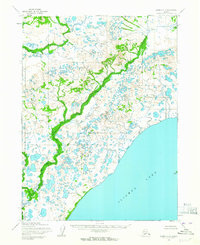
Iliamna Lake dominates the southeastern portion of this landscape, its expansive shoreline meeting a complex network of wetlands and tundra. The terrain is defined by a dense concentration of unnamed glacial ponds and small lakes that blanket the lowlands, illustrating the post-glacial hydrology of this region in the mid-1950s. The Kakhonak River provides the primary drainage route, winding through the center of the sheet as it flows toward the great lake. Based on aerial photography from 1953 and 1955, this topographic study captures the area in a purely natural state, with no roads, trails, or permanent settlements indicated. It serves as a precise record of the shoreline and water levels before more modern developments or environmental shifts influenced this part of the Alaska Peninsula.
Find a feature on this map
2 named features on this map. Tap any name to fly to it.
Don’t see what you’re looking for? This feature index may not catch every label — zoom into the map to look around manually.
Map Details
Editions of this 1954 Iliamna C-8 Map
2 editions found
Historical Maps of Unorganized Borough Through Time
732 maps found

1946 Lake Clark
Lake and Peninsula Borough, AK

1948 Mt Katmai
Lake and Peninsula Borough, AK

1951 Bristol Bay
Lake and Peninsula Borough, AK

1951 Dillingham A-1
Lake and Peninsula Borough, AK

1951 Iliamna A-6
Lake and Peninsula Borough, AK

1951 Iliamna A-7
Lake and Peninsula Borough, AK

1951 Iliamna A-8
Lake and Peninsula Borough, AK

1951 Iliamna B-5
Lake and Peninsula Borough, AK

1951 Iliamna B-6
Lake and Peninsula Borough, AK

1951 Iliamna B-7
Lake and Peninsula Borough, AK

1951 Karluk D-5
Lake and Peninsula Borough, AK

1951 Karluk D-6
Lake and Peninsula Borough, AK

1951 Lake Clark
Lake and Peninsula Borough, AK

1951 Mount Katmai A-6
Lake and Peninsula Borough, AK

1951 Mount Katmai B-3
Lake and Peninsula Borough, AK

1951 Mount Katmai B-5
Lake and Peninsula Borough, AK

1951 Mount Katmai B-6
Lake and Peninsula Borough, AK

1951 Mount Katmai C-2
Lake and Peninsula Borough, AK

1951 Mount Katmai C-3
Lake and Peninsula Borough, AK

1951 Mount Katmai C-4
Lake and Peninsula Borough, AK

1951 Mount Katmai C-5
Lake and Peninsula Borough, AK

1951 Mount Katmai C-6
Lake and Peninsula Borough, AK

1951 Mount Katmai D-3
Lake and Peninsula Borough, AK

1951 Mount Katmai D-4
Lake and Peninsula Borough, AK

1951 Mount Katmai D-6
Lake and Peninsula Borough, AK

1951 Mt. Katmai A-5
Lake and Peninsula Borough, AK

1951 Mt. Katmai B-4
Lake and Peninsula Borough, AK

1951 Mt. Katmai B-5
Lake and Peninsula Borough, AK

1951 Mt Katmai
Lake and Peninsula Borough, AK

1951 Naknek A-1
Lake and Peninsula Borough, AK

1951 Naknek A-2
Lake and Peninsula Borough, AK

1951 Naknek A-3
Lake and Peninsula Borough, AK

1951 Naknek A-4
Lake and Peninsula Borough, AK

1951 Naknek A-5
Lake and Peninsula Borough, AK

1951 Naknek B-1
Lake and Peninsula Borough, AK

1951 Naknek C-1
Lake and Peninsula Borough, AK

1951 Naknek D-1
Lake and Peninsula Borough, AK

1951 Stepovak Bay
Lake and Peninsula Borough, AK

1951 Sutwik Island
Lake and Peninsula Borough, AK

1951 Ugashik A-2
Lake and Peninsula Borough, AK

1951 Ugashik B-3
Lake and Peninsula Borough, AK

1951 Ugashik C-1
Lake and Peninsula Borough, AK

1951 Ugashik C-2
Lake and Peninsula Borough, AK

1951 Ugashik C-3
Lake and Peninsula Borough, AK

1951 Ugashik C-4
Lake and Peninsula Borough, AK

1951 Ugashik C-5
Lake and Peninsula Borough, AK

1951 Ugashik C-6
Lake and Peninsula Borough, AK

1951 Ugashik D-1
Lake and Peninsula Borough, AK

1951 Ugashik D-2
Lake and Peninsula Borough, AK

1951 Ugashik D-3
Lake and Peninsula Borough, AK

1951 Ugashik D-4
Lake and Peninsula Borough, AK

1951 Ugashik D-5 and D-6
Lake and Peninsula Borough, AK

1952 Dillingham A-2
Lake and Peninsula Borough, AK

1952 Dillingham A-3
Lake and Peninsula Borough, AK

1952 Iliamna A-8
Lake and Peninsula Borough, AK

1952 Naknek B-2
Lake and Peninsula Borough, AK

1952 Naknek B-3
Lake and Peninsula Borough, AK

1952 Naknek B-4
Lake and Peninsula Borough, AK

1952 Naknek B-5
Lake and Peninsula Borough, AK

1952 Naknek C-6
Lake and Peninsula Borough, AK

1953 Mount Katmai B-5
Lake and Peninsula Borough, AK

1953 Mount Katmai C-2
Lake and Peninsula Borough, AK

1953 Mount Katmai C-5
Lake and Peninsula Borough, AK

1953 Mt. Katmai B-6
Lake and Peninsula Borough, AK

1954 Dillingham B-1
Lake and Peninsula Borough, AK

1954 Dillingham B-2
Lake and Peninsula Borough, AK

1954 Iliamna B-5
Lake and Peninsula Borough, AK

1954 Iliamna B-6
Lake and Peninsula Borough, AK

1954 Iliamna B-8
Lake and Peninsula Borough, AK

1954 Iliamna C-3
Lake and Peninsula Borough, AK

1954 Iliamna C-4
Lake and Peninsula Borough, AK

1954 Iliamna C-5
Lake and Peninsula Borough, AK

1954 Iliamna C-6
Lake and Peninsula Borough, AK

1954 Iliamna C-7
Lake and Peninsula Borough, AK

1954 Iliamna C-8
Lake and Peninsula Borough, AK

1954 Iliamna D-3
Lake and Peninsula Borough, AK

1954 Iliamna D-4
Lake and Peninsula Borough, AK

1954 Iliamna D-5
Lake and Peninsula Borough, AK

1954 Iliamna D-6
Lake and Peninsula Borough, AK

1954 Iliamna D-7
Lake and Peninsula Borough, AK

1954 Iliamna D-8
Lake and Peninsula Borough, AK

1954 Lake Clark A-3
Lake and Peninsula Borough, AK

1954 Lake Clark A-4
Lake and Peninsula Borough, AK

1954 Lake Clark A-5
Lake and Peninsula Borough, AK

1954 Lake Clark A-6
Lake and Peninsula Borough, AK

1954 Lake Clark A-7
Lake and Peninsula Borough, AK

1954 Lake Clark A-8
Lake and Peninsula Borough, AK

1954 Lake Clark B-3
Lake and Peninsula Borough, AK

1954 Lake Clark B-4
Lake and Peninsula Borough, AK

1954 Lake Clark B-5
Lake and Peninsula Borough, AK

1954 Lake Clark B-6
Lake and Peninsula Borough, AK

1954 Lake Clark B-7
Lake and Peninsula Borough, AK

1954 Lake Clark B-8
Lake and Peninsula Borough, AK

1954 Lake Clark C-3
Lake and Peninsula Borough, AK

1954 Lake Clark C-4
Lake and Peninsula Borough, AK

1954 Lake Clark C-5
Lake and Peninsula Borough, AK

1954 Lake Clark C-6
Lake and Peninsula Borough, AK

1954 Lake Clark C-7
Lake and Peninsula Borough, AK

1954 Lake Clark C-8
Lake and Peninsula Borough, AK

1954 Lake Clark D-3
Lake and Peninsula Borough, AK

1954 Lake Clark D-4
Lake and Peninsula Borough, AK

1954 Lake Clark D-5
Lake and Peninsula Borough, AK

1954 Lake Clark D-6
Lake and Peninsula Borough, AK

1954 Lake Clark D-7
Lake and Peninsula Borough, AK

1954 Lake Clark D-8
Lake and Peninsula Borough, AK

1954 Sutwik Island D-3
Lake and Peninsula Borough, AK

1954 Ugashik A-3
Lake and Peninsula Borough, AK

1954 Ugashik B-4
Lake and Peninsula Borough, AK

1954 Ugashik B-5
Lake and Peninsula Borough, AK

1958 Lake Clark B-2
Lake and Peninsula Borough, AK

1958 Lake Clark C-2
Lake and Peninsula Borough, AK

1958 Lake Clark D-2
Lake and Peninsula Borough, AK

1958 Lake Clark
Lake and Peninsula Borough, AK

1963 Bristol Bay A-1
Lake and Peninsula Borough, AK

1963 Bristol Bay A-2
Lake and Peninsula Borough, AK

1963 Bristol Bay B-1
Lake and Peninsula Borough, AK

1963 Bristol Bay
Lake and Peninsula Borough, AK

1963 Chignik A-1
Lake and Peninsula Borough, AK

1963 Chignik A-2
Lake and Peninsula Borough, AK

1963 Chignik A-3
Lake and Peninsula Borough, AK

1963 Chignik A-4
Lake and Peninsula Borough, AK

1963 Chignik A-5
Lake and Peninsula Borough, AK

1963 Chignik B-1
Lake and Peninsula Borough, AK

1963 Chignik B-2
Lake and Peninsula Borough, AK

1963 Chignik B-3
Lake and Peninsula Borough, AK

1963 Chignik B-4
Lake and Peninsula Borough, AK

1963 Chignik B-5
Lake and Peninsula Borough, AK

1963 Chignik B-6
Lake and Peninsula Borough, AK

1963 Chignik C-1
Lake and Peninsula Borough, AK

1963 Chignik C-2
Lake and Peninsula Borough, AK

1963 Chignik C-3
Lake and Peninsula Borough, AK

1963 Chignik C-4
Lake and Peninsula Borough, AK

1963 Chignik D-1
Lake and Peninsula Borough, AK

1963 Chignik D-2
Lake and Peninsula Borough, AK

1963 Chignik D-3
Lake and Peninsula Borough, AK

1963 Stepovak Bay D-2
Lake and Peninsula Borough, AK

1963 Stepovak Bay D-3
Lake and Peninsula Borough, AK

1963 Stepovak Bay D-4
Lake and Peninsula Borough, AK

1963 Stepovak Bay D-5
Lake and Peninsula Borough, AK

1963 Stepovak Bay
Lake and Peninsula Borough, AK

1963 Sutwik Island B-6
Lake and Peninsula Borough, AK

1963 Sutwik Island C-4
Lake and Peninsula Borough, AK

1963 Sutwik Island C-5
Lake and Peninsula Borough, AK

1963 Sutwik Island C-6
Lake and Peninsula Borough, AK

1963 Sutwik Island D-4
Lake and Peninsula Borough, AK

1963 Sutwik Island D-5
Lake and Peninsula Borough, AK

1963 Sutwik Island D-6
Lake and Peninsula Borough, AK

1963 Sutwik Island
Lake and Peninsula Borough, AK

1963 Ugashik A-4
Lake and Peninsula Borough, AK

1963 Ugashik A-5
Lake and Peninsula Borough, AK

1963 Ugashik A-6
Lake and Peninsula Borough, AK

1963 Ugashik B-6
Lake and Peninsula Borough, AK

1964 Mt. Katmai
Lake and Peninsula Borough, AK

1967 Bristol Bay
Lake and Peninsula Borough, AK

1969 Stepovak Bay
Lake and Peninsula Borough, AK

1989 Sutwik Island D-2
Lake and Peninsula Borough, AK

2018 Iliamna A-5 NW
Lake and Peninsula Borough, AK

2018 Iliamna A-5 SW
Lake and Peninsula Borough, AK

2018 Iliamna B-4 NE
Lake and Peninsula Borough, AK

2018 Iliamna B-4 NW
Lake and Peninsula Borough, AK

2018 Iliamna B-5 NE
Lake and Peninsula Borough, AK

2018 Iliamna B-5 NW
Lake and Peninsula Borough, AK

2018 Iliamna B-5 SE
Lake and Peninsula Borough, AK

2018 Iliamna B-5 SW
Lake and Peninsula Borough, AK

2018 Iliamna C-3 NW
Lake and Peninsula Borough, AK

2018 Iliamna C-4 NE
Lake and Peninsula Borough, AK

2018 Iliamna C-4 NW
Lake and Peninsula Borough, AK

2018 Iliamna C-4 SE
Lake and Peninsula Borough, AK

2018 Iliamna C-4 SW
Lake and Peninsula Borough, AK

2018 Iliamna C-5 NE
Lake and Peninsula Borough, AK

2018 Iliamna C-5 NW
Lake and Peninsula Borough, AK

2018 Iliamna C-5 SE
Lake and Peninsula Borough, AK

2018 Iliamna C-5 SW
Lake and Peninsula Borough, AK

2018 Iliamna D-3 NE
Lake and Peninsula Borough, AK

2018 Iliamna D-3 SE
Lake and Peninsula Borough, AK

2018 Iliamna D-3 SW
Lake and Peninsula Borough, AK

2018 Iliamna D-4 NE
Lake and Peninsula Borough, AK

2018 Iliamna D-4 NW
Lake and Peninsula Borough, AK

2018 Iliamna D-4 SE
Lake and Peninsula Borough, AK

2018 Iliamna D-4 SW
Lake and Peninsula Borough, AK

2018 Iliamna D-5 NE
Lake and Peninsula Borough, AK

2018 Iliamna D-5 NW
Lake and Peninsula Borough, AK

2018 Iliamna D-5 SE
Lake and Peninsula Borough, AK

2018 Iliamna D-5 SW
Lake and Peninsula Borough, AK

2018 Lake Clark A-2 NW
Lake and Peninsula Borough, AK

2018 Lake Clark A-2 SW
Lake and Peninsula Borough, AK

2018 Lake Clark A-3 NE
Lake and Peninsula Borough, AK

2018 Lake Clark A-3 SE
Lake and Peninsula Borough, AK

2018 Lake Clark A-4 NE
Lake and Peninsula Borough, AK

2018 Lake Clark A-4 NW
Lake and Peninsula Borough, AK

2018 Lake Clark A-4 SE
Lake and Peninsula Borough, AK

2018 Lake Clark A-4 SW
Lake and Peninsula Borough, AK

2018 Lake Clark A-5 NE
Lake and Peninsula Borough, AK

2018 Lake Clark A-5 NW
Lake and Peninsula Borough, AK

2018 Lake Clark A-5 SE
Lake and Peninsula Borough, AK

2018 Lake Clark A-5 SW
Lake and Peninsula Borough, AK

2018 Lake Clark B-2 NW
Lake and Peninsula Borough, AK

2018 Lake Clark B-2 SW
Lake and Peninsula Borough, AK

2018 Lake Clark B-3 NE
Lake and Peninsula Borough, AK

2018 Lake Clark B-3 SE
Lake and Peninsula Borough, AK

2018 Lake Clark B-4 NE
Lake and Peninsula Borough, AK

2018 Lake Clark B-4 NW
Lake and Peninsula Borough, AK

2018 Lake Clark B-4 SE
Lake and Peninsula Borough, AK

2018 Lake Clark B-4 SW
Lake and Peninsula Borough, AK

2018 Lake Clark B-5 NE
Lake and Peninsula Borough, AK

2018 Lake Clark B-5 NW
Lake and Peninsula Borough, AK

2018 Lake Clark B-5 SE
Lake and Peninsula Borough, AK

2018 Lake Clark B-5 SW
Lake and Peninsula Borough, AK

2018 Lake Clark C-2 NE
Lake and Peninsula Borough, AK

2018 Lake Clark C-2 NW
Lake and Peninsula Borough, AK

2018 Lake Clark C-2 SE
Lake and Peninsula Borough, AK

2018 Lake Clark C-2 SW
Lake and Peninsula Borough, AK

2018 Lake Clark C-3 NE
Lake and Peninsula Borough, AK

2018 Lake Clark C-3 SE
Lake and Peninsula Borough, AK

2018 Lake Clark C-4 NE
Lake and Peninsula Borough, AK

2018 Lake Clark C-4 NW
Lake and Peninsula Borough, AK

2018 Lake Clark C-4 SE
Lake and Peninsula Borough, AK

2018 Lake Clark C-4 SW
Lake and Peninsula Borough, AK

2018 Lake Clark C-5 NE
Lake and Peninsula Borough, AK

2018 Lake Clark C-5 NW
Lake and Peninsula Borough, AK

2018 Lake Clark C-5 SE
Lake and Peninsula Borough, AK

2018 Lake Clark C-5 SW
Lake and Peninsula Borough, AK

2018 Lake Clark D-2 SE
Lake and Peninsula Borough, AK

2018 Lake Clark D-2 SW
Lake and Peninsula Borough, AK

2018 Lake Clark D-3 SE
Lake and Peninsula Borough, AK

2018 Lake Clark D-4 SE
Lake and Peninsula Borough, AK

2018 Lake Clark D-4 SW
Lake and Peninsula Borough, AK

2018 Lake Clark D-5 SE
Lake and Peninsula Borough, AK

2018 Lake Clark D-5 SW
Lake and Peninsula Borough, AK

2019 Bristol Bay A-1 NE
Lake and Peninsula Borough, AK

2019 Bristol Bay A-1 NW
Lake and Peninsula Borough, AK

2019 Bristol Bay A-1 SE
Lake and Peninsula Borough, AK

2019 Bristol Bay A-1 SW
Lake and Peninsula Borough, AK

2019 Bristol Bay A-2 NE
Lake and Peninsula Borough, AK

2019 Bristol Bay A-2 NW
Lake and Peninsula Borough, AK

2019 Bristol Bay A-2 OE W SE
Lake and Peninsula Borough, AK

2019 Bristol Bay A-2 SE
Lake and Peninsula Borough, AK

2019 Bristol Bay A-2 SW
Lake and Peninsula Borough, AK

2019 Bristol Bay B-1 NE
Lake and Peninsula Borough, AK

2019 Bristol Bay B-1 NW
Lake and Peninsula Borough, AK

2019 Bristol Bay B-1 OE W SE
Lake and Peninsula Borough, AK

2019 Bristol Bay B-1 SE
Lake and Peninsula Borough, AK

2019 Bristol Bay B-1 SW
Lake and Peninsula Borough, AK

2019 Dillingham A-1 NE
Lake and Peninsula Borough, AK

2019 Dillingham A-1 NW
Lake and Peninsula Borough, AK

2019 Dillingham A-1 SE
Lake and Peninsula Borough, AK

2019 Dillingham A-1 SW
Lake and Peninsula Borough, AK

2019 Dillingham A-2 NE
Lake and Peninsula Borough, AK

2019 Dillingham A-2 NW
Lake and Peninsula Borough, AK

2019 Dillingham A-2 SE
Lake and Peninsula Borough, AK

2019 Dillingham A-2 SW
Lake and Peninsula Borough, AK

2019 Dillingham A-3 NE
Lake and Peninsula Borough, AK

2019 Dillingham A-3 NW
Lake and Peninsula Borough, AK

2019 Dillingham A-3 SE
Lake and Peninsula Borough, AK

2019 Dillingham A-3 SW
Lake and Peninsula Borough, AK

2019 Dillingham A-4 NE
Lake and Peninsula Borough, AK

2019 Dillingham B-1 NE
Lake and Peninsula Borough, AK

2019 Dillingham B-1 NW
Lake and Peninsula Borough, AK

2019 Dillingham B-1 SE
Lake and Peninsula Borough, AK

2019 Dillingham B-1 SW
Lake and Peninsula Borough, AK

2019 Dillingham B-2 NE
Lake and Peninsula Borough, AK

2019 Dillingham B-2 NW
Lake and Peninsula Borough, AK

2019 Dillingham B-2 SE
Lake and Peninsula Borough, AK

2019 Dillingham B-2 SW
Lake and Peninsula Borough, AK

2019 Dillingham B-3 SE
Lake and Peninsula Borough, AK

2019 Dillingham C-1 SE
Lake and Peninsula Borough, AK

2019 Dillingham C-1 SW
Lake and Peninsula Borough, AK

2019 Iliamna A-6 NE
Lake and Peninsula Borough, AK

2019 Iliamna A-6 NW
Lake and Peninsula Borough, AK

2019 Iliamna A-6 SE
Lake and Peninsula Borough, AK

2019 Iliamna A-6 SW
Lake and Peninsula Borough, AK

2019 Iliamna A-7 NE
Lake and Peninsula Borough, AK

2019 Iliamna A-7 NW
Lake and Peninsula Borough, AK

2019 Iliamna A-7 SE
Lake and Peninsula Borough, AK

2019 Iliamna A-7 SW
Lake and Peninsula Borough, AK

2019 Iliamna A-8 NE
Lake and Peninsula Borough, AK

2019 Iliamna A-8 NW
Lake and Peninsula Borough, AK

2019 Iliamna A-8 SE
Lake and Peninsula Borough, AK

2019 Iliamna A-8 SW
Lake and Peninsula Borough, AK

2019 Iliamna B-6 NE
Lake and Peninsula Borough, AK

2019 Iliamna B-6 NW
Lake and Peninsula Borough, AK

2019 Iliamna B-6 SE
Lake and Peninsula Borough, AK

2019 Iliamna B-6 SW
Lake and Peninsula Borough, AK

2019 Iliamna B-7 NE
Lake and Peninsula Borough, AK

2019 Iliamna B-7 SE
Lake and Peninsula Borough, AK

2019 Iliamna B-7 SW
Lake and Peninsula Borough, AK

2019 Iliamna B-8 NW
Lake and Peninsula Borough, AK

2019 Iliamna B-8 SE
Lake and Peninsula Borough, AK

2019 Iliamna B-8 SW
Lake and Peninsula Borough, AK

2019 Iliamna C-6 NE
Lake and Peninsula Borough, AK

2019 Iliamna C-6 NW
Lake and Peninsula Borough, AK

2019 Iliamna C-6 SE
Lake and Peninsula Borough, AK

2019 Iliamna C-7 NE
Lake and Peninsula Borough, AK

2019 Iliamna C-7 NW
Lake and Peninsula Borough, AK

2019 Iliamna C-7 SE
Lake and Peninsula Borough, AK

2019 Iliamna C-7 SW
Lake and Peninsula Borough, AK

2019 Iliamna C-8 NE
Lake and Peninsula Borough, AK

2019 Iliamna C-8 NW
Lake and Peninsula Borough, AK

2019 Iliamna C-8 SE
Lake and Peninsula Borough, AK

2019 Iliamna C-8 SW
Lake and Peninsula Borough, AK

2019 Iliamna D-6 NE
Lake and Peninsula Borough, AK

2019 Iliamna D-6 NW
Lake and Peninsula Borough, AK

2019 Iliamna D-6 SE
Lake and Peninsula Borough, AK

2019 Iliamna D-6 SW
Lake and Peninsula Borough, AK

2019 Iliamna D-7 NE
Lake and Peninsula Borough, AK

2019 Iliamna D-7 NW
Lake and Peninsula Borough, AK

2019 Iliamna D-7 SE
Lake and Peninsula Borough, AK

2019 Iliamna D-7 SW
Lake and Peninsula Borough, AK

2019 Iliamna D-8 NE
Lake and Peninsula Borough, AK

2019 Iliamna D-8 NW
Lake and Peninsula Borough, AK

2019 Iliamna D-8 SE
Lake and Peninsula Borough, AK

2019 Iliamna D-8 SW
Lake and Peninsula Borough, AK

2019 Karluk C-6 NW
Lake and Peninsula Borough, AK

2019 Karluk D-5 NE
Lake and Peninsula Borough, AK

2019 Karluk D-5 NW
Lake and Peninsula Borough, AK

2019 Karluk D-5 SW
Lake and Peninsula Borough, AK

2019 Karluk D-6 NE
Lake and Peninsula Borough, AK

2019 Karluk D-6 NW
Lake and Peninsula Borough, AK

2019 Karluk D-6 SE
Lake and Peninsula Borough, AK

2019 Karluk D-6 SW
Lake and Peninsula Borough, AK

2019 Lake Clark A-6 NE
Lake and Peninsula Borough, AK

2019 Lake Clark A-6 NW
Lake and Peninsula Borough, AK

2019 Lake Clark A-6 SE
Lake and Peninsula Borough, AK

2019 Lake Clark A-6 SW
Lake and Peninsula Borough, AK

2019 Lake Clark A-7 NE
Lake and Peninsula Borough, AK

2019 Lake Clark A-7 NW
Lake and Peninsula Borough, AK

2019 Lake Clark A-7 SE
Lake and Peninsula Borough, AK

2019 Lake Clark A-7 SW
Lake and Peninsula Borough, AK

2019 Lake Clark A-8 NE
Lake and Peninsula Borough, AK

2019 Lake Clark A-8 NW
Lake and Peninsula Borough, AK

2019 Lake Clark A-8 SE
Lake and Peninsula Borough, AK

2019 Lake Clark A-8 SW
Lake and Peninsula Borough, AK

2019 Lake Clark B-6 NE
Lake and Peninsula Borough, AK

2019 Lake Clark B-6 NW
Lake and Peninsula Borough, AK

2019 Lake Clark B-6 SE
Lake and Peninsula Borough, AK

2019 Lake Clark B-6 SW
Lake and Peninsula Borough, AK

2019 Lake Clark B-7 NE
Lake and Peninsula Borough, AK

2019 Lake Clark B-7 NW
Lake and Peninsula Borough, AK

2019 Lake Clark B-7 SE
Lake and Peninsula Borough, AK

2019 Lake Clark B-7 SW
Lake and Peninsula Borough, AK

2019 Lake Clark B-8 NE
Lake and Peninsula Borough, AK

2019 Lake Clark B-8 NW
Lake and Peninsula Borough, AK

2019 Lake Clark B-8 SE
Lake and Peninsula Borough, AK

2019 Lake Clark B-8 SW
Lake and Peninsula Borough, AK

2019 Lake Clark C-6 NE
Lake and Peninsula Borough, AK

2019 Lake Clark C-6 NW
Lake and Peninsula Borough, AK

2019 Lake Clark C-6 SE
Lake and Peninsula Borough, AK

2019 Lake Clark C-6 SW
Lake and Peninsula Borough, AK

2019 Lake Clark C-7 NE
Lake and Peninsula Borough, AK

2019 Lake Clark C-7 NW
Lake and Peninsula Borough, AK

2019 Lake Clark C-7 SE
Lake and Peninsula Borough, AK

2019 Lake Clark C-7 SW
Lake and Peninsula Borough, AK

2019 Lake Clark C-8 NE
Lake and Peninsula Borough, AK

2019 Lake Clark C-8 NW
Lake and Peninsula Borough, AK

2019 Lake Clark C-8 SE
Lake and Peninsula Borough, AK

2019 Lake Clark C-8 SW
Lake and Peninsula Borough, AK

2019 Lake Clark D-6 SE
Lake and Peninsula Borough, AK

2019 Lake Clark D-6 SW
Lake and Peninsula Borough, AK

2019 Lake Clark D-7 SE
Lake and Peninsula Borough, AK

2019 Lake Clark D-7 SW
Lake and Peninsula Borough, AK

2019 Lake Clark D-8 SE
Lake and Peninsula Borough, AK

2019 Lake Clark D-8 SW
Lake and Peninsula Borough, AK

2019 Mount Katmai A-1 NE
Lake and Peninsula Borough, AK

2019 Mount Katmai A-1 NW
Lake and Peninsula Borough, AK

2019 Mount Katmai A-1 SW
Lake and Peninsula Borough, AK

2019 Mount Katmai A-2 NE
Lake and Peninsula Borough, AK

2019 Mount Katmai A-2 NW
Lake and Peninsula Borough, AK

2019 Mount Katmai A-2 SE
Lake and Peninsula Borough, AK

2019 Mount Katmai A-2 SW
Lake and Peninsula Borough, AK

2019 Mount Katmai A-3 NE
Lake and Peninsula Borough, AK

2019 Mount Katmai A-3 NW
Lake and Peninsula Borough, AK

2019 Mount Katmai A-3 SE
Lake and Peninsula Borough, AK

2019 Mount Katmai A-3 SW
Lake and Peninsula Borough, AK

2019 Mount Katmai A-4 NE
Lake and Peninsula Borough, AK

2019 Mount Katmai A-4 NW
Lake and Peninsula Borough, AK

2019 Mount Katmai A-4 SE
Lake and Peninsula Borough, AK

2019 Mount Katmai A-4 SW
Lake and Peninsula Borough, AK

2019 Mount Katmai A-5 NE
Lake and Peninsula Borough, AK

2019 Mount Katmai A-5 NW
Lake and Peninsula Borough, AK

2019 Mount Katmai A-5 SE
Lake and Peninsula Borough, AK

2019 Mount Katmai A-5 SW
Lake and Peninsula Borough, AK

2019 Mount Katmai A-6 NE
Lake and Peninsula Borough, AK

2019 Mount Katmai A-6 NW
Lake and Peninsula Borough, AK

2019 Mount Katmai A-6 SE
Lake and Peninsula Borough, AK

2019 Mount Katmai A-6 SW
Lake and Peninsula Borough, AK

2019 Mount Katmai B-1 NE
Lake and Peninsula Borough, AK

2019 Mount Katmai B-1 NW
Lake and Peninsula Borough, AK

2019 Mount Katmai B-1 OE E NW
Lake and Peninsula Borough, AK

2019 Mount Katmai B-1 OE E SW
Lake and Peninsula Borough, AK

2019 Mount Katmai B-1 SE
Lake and Peninsula Borough, AK

2019 Mount Katmai B-1 SW
Lake and Peninsula Borough, AK

2019 Mount Katmai B-2 NE
Lake and Peninsula Borough, AK

2019 Mount Katmai B-2 NW
Lake and Peninsula Borough, AK

2019 Mount Katmai B-2 SE
Lake and Peninsula Borough, AK

2019 Mount Katmai B-2 SW
Lake and Peninsula Borough, AK

2019 Mount Katmai B-3 NE
Lake and Peninsula Borough, AK

2019 Mount Katmai B-3 NW
Lake and Peninsula Borough, AK

2019 Mount Katmai B-3 SE
Lake and Peninsula Borough, AK

2019 Mount Katmai B-3 SW
Lake and Peninsula Borough, AK

2019 Mount Katmai B-4 NE
Lake and Peninsula Borough, AK

2019 Mount Katmai B-4 NW
Lake and Peninsula Borough, AK

2019 Mount Katmai B-4 SE
Lake and Peninsula Borough, AK

2019 Mount Katmai B-4 SW
Lake and Peninsula Borough, AK

2019 Mount Katmai B-5 NE
Lake and Peninsula Borough, AK

2019 Mount Katmai B-5 NW
Lake and Peninsula Borough, AK

2019 Mount Katmai B-5 SE
Lake and Peninsula Borough, AK

2019 Mount Katmai B-5 SW
Lake and Peninsula Borough, AK

2019 Mount Katmai B-6 NE
Lake and Peninsula Borough, AK

2019 Mount Katmai B-6 NW
Lake and Peninsula Borough, AK

2019 Mount Katmai B-6 SE
Lake and Peninsula Borough, AK

2019 Mount Katmai B-6 SW
Lake and Peninsula Borough, AK

2019 Mount Katmai C-1 SE
Lake and Peninsula Borough, AK

2019 Mount Katmai C-1 SW
Lake and Peninsula Borough, AK

2019 Mount Katmai C-2 SE
Lake and Peninsula Borough, AK

2019 Mount Katmai C-2 SW
Lake and Peninsula Borough, AK

2019 Mount Katmai C-3 NE
Lake and Peninsula Borough, AK

2019 Mount Katmai C-3 NW
Lake and Peninsula Borough, AK

2019 Mount Katmai C-3 SE
Lake and Peninsula Borough, AK

2019 Mount Katmai C-3 SW
Lake and Peninsula Borough, AK

2019 Mount Katmai C-4 NE
Lake and Peninsula Borough, AK

2019 Mount Katmai C-4 NW
Lake and Peninsula Borough, AK

2019 Mount Katmai C-4 SE
Lake and Peninsula Borough, AK

2019 Mount Katmai C-4 SW
Lake and Peninsula Borough, AK

2019 Mount Katmai C-5 NE
Lake and Peninsula Borough, AK

2019 Mount Katmai C-5 NW
Lake and Peninsula Borough, AK

2019 Mount Katmai C-5 SE
Lake and Peninsula Borough, AK

2019 Mount Katmai C-5 SW
Lake and Peninsula Borough, AK

2019 Mount Katmai C-6 NE
Lake and Peninsula Borough, AK

2019 Mount Katmai C-6 NW
Lake and Peninsula Borough, AK

2019 Mount Katmai C-6 SE
Lake and Peninsula Borough, AK

2019 Mount Katmai C-6 SW
Lake and Peninsula Borough, AK

2019 Mount Katmai D-3 NE
Lake and Peninsula Borough, AK

2019 Mount Katmai D-3 NW
Lake and Peninsula Borough, AK

2019 Mount Katmai D-3 SE
Lake and Peninsula Borough, AK

2019 Mount Katmai D-3 SW
Lake and Peninsula Borough, AK

2019 Mount Katmai D-4 NE
Lake and Peninsula Borough, AK

2019 Mount Katmai D-4 NW
Lake and Peninsula Borough, AK

2019 Mount Katmai D-4 SE
Lake and Peninsula Borough, AK

2019 Mount Katmai D-4 SW
Lake and Peninsula Borough, AK

2019 Mount Katmai D-5 NE
Lake and Peninsula Borough, AK

2019 Mount Katmai D-5 NW
Lake and Peninsula Borough, AK

2019 Mount Katmai D-5 SE
Lake and Peninsula Borough, AK

2019 Mount Katmai D-5 SW
Lake and Peninsula Borough, AK

2019 Mount Katmai D-6 NE
Lake and Peninsula Borough, AK

2019 Mount Katmai D-6 NW
Lake and Peninsula Borough, AK

2019 Mount Katmai D-6 SE
Lake and Peninsula Borough, AK

2019 Mount Katmai D-6 SW
Lake and Peninsula Borough, AK

2019 Naknek A-1 NE
Lake and Peninsula Borough, AK

2019 Naknek A-1 NW
Lake and Peninsula Borough, AK

2019 Naknek A-1 SE
Lake and Peninsula Borough, AK

2019 Naknek A-1 SW
Lake and Peninsula Borough, AK

2019 Naknek A-2 NE
Lake and Peninsula Borough, AK

2019 Naknek A-2 NW
Lake and Peninsula Borough, AK

2019 Naknek A-2 SE
Lake and Peninsula Borough, AK

2019 Naknek A-2 SW
Lake and Peninsula Borough, AK

2019 Naknek A-3 NE
Lake and Peninsula Borough, AK

2019 Naknek A-3 NW
Lake and Peninsula Borough, AK

2019 Naknek A-3 SE
Lake and Peninsula Borough, AK

2019 Naknek A-3 SW
Lake and Peninsula Borough, AK

2019 Naknek A-4 NE
Lake and Peninsula Borough, AK

2019 Naknek A-4 NW
Lake and Peninsula Borough, AK

2019 Naknek A-4 SE
Lake and Peninsula Borough, AK

2019 Naknek A-4 SW
Lake and Peninsula Borough, AK

2019 Naknek A-5 NE
Lake and Peninsula Borough, AK

2019 Naknek A-5 NW
Lake and Peninsula Borough, AK

2019 Naknek A-5 SE
Lake and Peninsula Borough, AK

2019 Naknek A-5 SW
Lake and Peninsula Borough, AK

2019 Naknek B-1 NE
Lake and Peninsula Borough, AK

2019 Naknek B-1 NW
Lake and Peninsula Borough, AK

2019 Naknek B-1 SE
Lake and Peninsula Borough, AK

2019 Naknek B-1 SW
Lake and Peninsula Borough, AK

2019 Naknek B-2 NE
Lake and Peninsula Borough, AK

2019 Naknek B-2 NW
Lake and Peninsula Borough, AK

2019 Naknek B-2 SE
Lake and Peninsula Borough, AK

2019 Naknek B-2 SW
Lake and Peninsula Borough, AK

2019 Naknek B-3 NE
Lake and Peninsula Borough, AK

2019 Naknek B-3 NW
Lake and Peninsula Borough, AK

2019 Naknek B-3 SE
Lake and Peninsula Borough, AK

2019 Naknek B-3 SW
Lake and Peninsula Borough, AK

2019 Naknek B-4 NE
Lake and Peninsula Borough, AK

2019 Naknek B-4 NW
Lake and Peninsula Borough, AK

2019 Naknek B-4 SE
Lake and Peninsula Borough, AK

2019 Naknek B-4 SW
Lake and Peninsula Borough, AK

2019 Naknek B-5 NE
Lake and Peninsula Borough, AK

2019 Naknek B-5 NW
Lake and Peninsula Borough, AK

2019 Naknek B-5 SE
Lake and Peninsula Borough, AK

2019 Naknek B-5 SW
Lake and Peninsula Borough, AK

2019 Naknek C-1 NE
Lake and Peninsula Borough, AK

2019 Naknek C-1 NW
Lake and Peninsula Borough, AK

2019 Naknek C-1 SE
Lake and Peninsula Borough, AK

2019 Naknek C-1 SW
Lake and Peninsula Borough, AK

2019 Naknek C-2 SE
Lake and Peninsula Borough, AK

2019 Naknek C-2 SW
Lake and Peninsula Borough, AK

2019 Naknek C-3 SE
Lake and Peninsula Borough, AK

2019 Naknek C-3 SW
Lake and Peninsula Borough, AK

2019 Naknek C-4 SE
Lake and Peninsula Borough, AK

2019 Naknek C-4 SW
Lake and Peninsula Borough, AK

2019 Naknek C-5 SE
Lake and Peninsula Borough, AK

2019 Naknek D-1 NE
Lake and Peninsula Borough, AK

2019 Naknek D-1 NW
Lake and Peninsula Borough, AK

2019 Naknek D-1 SE
Lake and Peninsula Borough, AK

2019 Naknek D-1 SW
Lake and Peninsula Borough, AK

2019 Naknek D-2 NE
Lake and Peninsula Borough, AK

2019 Naknek D-2 NW
Lake and Peninsula Borough, AK

2019 Naknek D-3 NE
Lake and Peninsula Borough, AK

2019 Naknek D-3 NW
Lake and Peninsula Borough, AK

2019 Naknek D-4 NE
Lake and Peninsula Borough, AK

2019 Naknek D-4 NW
Lake and Peninsula Borough, AK

2019 Sutwik Island A-3 NE
Lake and Peninsula Borough, AK

2019 Sutwik Island A-3 OE E SW
Lake and Peninsula Borough, AK

2019 Sutwik Island A-3 SE
Lake and Peninsula Borough, AK

2019 Sutwik Island B-6 NE
Lake and Peninsula Borough, AK

2019 Sutwik Island B-6 NW
Lake and Peninsula Borough, AK

2019 Sutwik Island B-6 SE
Lake and Peninsula Borough, AK

2019 Sutwik Island B-6 SW
Lake and Peninsula Borough, AK

2019 Sutwik Island C-4 NE
Lake and Peninsula Borough, AK

2019 Sutwik Island C-4 OE E SW
Lake and Peninsula Borough, AK

2019 Sutwik Island C-4 SE
Lake and Peninsula Borough, AK

2019 Sutwik Island C-4 SW
Lake and Peninsula Borough, AK

2019 Sutwik Island C-5 NE
Lake and Peninsula Borough, AK

2019 Sutwik Island C-5 NW
Lake and Peninsula Borough, AK

2019 Sutwik Island C-5 SE
Lake and Peninsula Borough, AK

2019 Sutwik Island C-5 SW
Lake and Peninsula Borough, AK

2019 Sutwik Island C-6 NE
Lake and Peninsula Borough, AK

2019 Sutwik Island C-6 NW
Lake and Peninsula Borough, AK

2019 Sutwik Island C-6 SE
Lake and Peninsula Borough, AK

2019 Sutwik Island C-6 SW
Lake and Peninsula Borough, AK

2019 Sutwik Island D-2 NE
Lake and Peninsula Borough, AK

2019 Sutwik Island D-2 NW
Lake and Peninsula Borough, AK

2019 Sutwik Island D-3 NE
Lake and Peninsula Borough, AK

2019 Sutwik Island D-3 NW
Lake and Peninsula Borough, AK

2019 Sutwik Island D-3 SE
Lake and Peninsula Borough, AK

2019 Sutwik Island D-3 SW
Lake and Peninsula Borough, AK

2019 Sutwik Island D-4 NE
Lake and Peninsula Borough, AK

2019 Sutwik Island D-4 NW
Lake and Peninsula Borough, AK

2019 Sutwik Island D-4 SE
Lake and Peninsula Borough, AK

2019 Sutwik Island D-4 SW
Lake and Peninsula Borough, AK

2019 Sutwik Island D-5 NE
Lake and Peninsula Borough, AK

2019 Sutwik Island D-5 NW
Lake and Peninsula Borough, AK

2019 Sutwik Island D-5 SE
Lake and Peninsula Borough, AK

2019 Sutwik Island D-5 SW
Lake and Peninsula Borough, AK

2019 Sutwik Island D-6 NE
Lake and Peninsula Borough, AK

2019 Sutwik Island D-6 NW
Lake and Peninsula Borough, AK

2019 Sutwik Island D-6 SE
Lake and Peninsula Borough, AK

2019 Sutwik Island D-6 SW
Lake and Peninsula Borough, AK

2019 Ugashik A-2 NE
Lake and Peninsula Borough, AK

2019 Ugashik A-2 NW
Lake and Peninsula Borough, AK

2019 Ugashik A-2 OE E NW
Lake and Peninsula Borough, AK

2019 Ugashik A-2 SE
Lake and Peninsula Borough, AK

2019 Ugashik A-2 SW
Lake and Peninsula Borough, AK

2019 Ugashik A-3 NE
Lake and Peninsula Borough, AK

2019 Ugashik A-3 NW
Lake and Peninsula Borough, AK

2019 Ugashik A-3 SE
Lake and Peninsula Borough, AK

2019 Ugashik A-3 SW
Lake and Peninsula Borough, AK

2019 Ugashik A-4 NE
Lake and Peninsula Borough, AK

2019 Ugashik A-4 NW
Lake and Peninsula Borough, AK

2019 Ugashik A-4 SE
Lake and Peninsula Borough, AK

2019 Ugashik A-4 SW
Lake and Peninsula Borough, AK

2019 Ugashik A-5 NE
Lake and Peninsula Borough, AK

2019 Ugashik A-5 NW
Lake and Peninsula Borough, AK

2019 Ugashik A-5 SE
Lake and Peninsula Borough, AK

2019 Ugashik A-5 SW
Lake and Peninsula Borough, AK

2019 Ugashik A-6 NE
Lake and Peninsula Borough, AK

2019 Ugashik A-6 NW
Lake and Peninsula Borough, AK

2019 Ugashik A-6 SE
Lake and Peninsula Borough, AK

2019 Ugashik A-6 SW
Lake and Peninsula Borough, AK

2019 Ugashik B-1 NE
Lake and Peninsula Borough, AK

2019 Ugashik B-1 NW
Lake and Peninsula Borough, AK

2019 Ugashik B-1 SE
Lake and Peninsula Borough, AK

2019 Ugashik B-1 SW
Lake and Peninsula Borough, AK

2019 Ugashik B-2 NE
Lake and Peninsula Borough, AK

2019 Ugashik B-2 NW
Lake and Peninsula Borough, AK

2019 Ugashik B-2 SE
Lake and Peninsula Borough, AK

2019 Ugashik B-2 SW
Lake and Peninsula Borough, AK

2019 Ugashik B-3 NE
Lake and Peninsula Borough, AK

2019 Ugashik B-3 NW
Lake and Peninsula Borough, AK

2019 Ugashik B-3 SE
Lake and Peninsula Borough, AK

2019 Ugashik B-3 SW
Lake and Peninsula Borough, AK

2019 Ugashik B-4 NE
Lake and Peninsula Borough, AK

2019 Ugashik B-4 NW
Lake and Peninsula Borough, AK

2019 Ugashik B-4 SE
Lake and Peninsula Borough, AK

2019 Ugashik B-4 SW
Lake and Peninsula Borough, AK

2019 Ugashik B-5 NE
Lake and Peninsula Borough, AK

2019 Ugashik B-5 NW
Lake and Peninsula Borough, AK

2019 Ugashik B-5 SE
Lake and Peninsula Borough, AK

2019 Ugashik B-5 SW
Lake and Peninsula Borough, AK

2019 Ugashik B-6 NE
Lake and Peninsula Borough, AK

2019 Ugashik B-6 NW
Lake and Peninsula Borough, AK

2019 Ugashik B-6 SE
Lake and Peninsula Borough, AK

2019 Ugashik B-6 SW
Lake and Peninsula Borough, AK

2019 Ugashik C-1 NE
Lake and Peninsula Borough, AK

2019 Ugashik C-1 NW
Lake and Peninsula Borough, AK

2019 Ugashik C-1 SE
Lake and Peninsula Borough, AK

2019 Ugashik C-1 SW
Lake and Peninsula Borough, AK

2019 Ugashik C-2 NE
Lake and Peninsula Borough, AK

2019 Ugashik C-2 NW
Lake and Peninsula Borough, AK

2019 Ugashik C-2 SE
Lake and Peninsula Borough, AK

2019 Ugashik C-2 SW
Lake and Peninsula Borough, AK

2019 Ugashik C-3 NE
Lake and Peninsula Borough, AK

2019 Ugashik C-3 NW
Lake and Peninsula Borough, AK

2019 Ugashik C-3 SE
Lake and Peninsula Borough, AK

2019 Ugashik C-3 SW
Lake and Peninsula Borough, AK

2019 Ugashik C-4 NE
Lake and Peninsula Borough, AK

2019 Ugashik C-4 NW
Lake and Peninsula Borough, AK

2019 Ugashik C-4 SE
Lake and Peninsula Borough, AK

2019 Ugashik C-4 SW
Lake and Peninsula Borough, AK

2019 Ugashik C-5 NE
Lake and Peninsula Borough, AK

2019 Ugashik C-5 NW
Lake and Peninsula Borough, AK

2019 Ugashik C-5 SE
Lake and Peninsula Borough, AK

2019 Ugashik C-5 SW
Lake and Peninsula Borough, AK

2019 Ugashik C-6 NE
Lake and Peninsula Borough, AK

2019 Ugashik C-6 SE
Lake and Peninsula Borough, AK

2019 Ugashik C-6 SW
Lake and Peninsula Borough, AK

2019 Ugashik D-1 NE
Lake and Peninsula Borough, AK

2019 Ugashik D-1 NW
Lake and Peninsula Borough, AK

2019 Ugashik D-1 SE
Lake and Peninsula Borough, AK

2019 Ugashik D-1 SW
Lake and Peninsula Borough, AK

2019 Ugashik D-2 NE
Lake and Peninsula Borough, AK

2019 Ugashik D-2 NW
Lake and Peninsula Borough, AK

2019 Ugashik D-2 SE
Lake and Peninsula Borough, AK

2019 Ugashik D-2 SW
Lake and Peninsula Borough, AK

2019 Ugashik D-3 NE
Lake and Peninsula Borough, AK

2019 Ugashik D-3 NW
Lake and Peninsula Borough, AK

2019 Ugashik D-3 SE
Lake and Peninsula Borough, AK

2019 Ugashik D-3 SW
Lake and Peninsula Borough, AK

2019 Ugashik D-4 NE
Lake and Peninsula Borough, AK

2019 Ugashik D-4 NW
Lake and Peninsula Borough, AK

2019 Ugashik D-4 SE
Lake and Peninsula Borough, AK

2019 Ugashik D-4 SW
Lake and Peninsula Borough, AK

2019 Ugashik D-5 NE
Lake and Peninsula Borough, AK

2019 Ugashik D-5 NW
Lake and Peninsula Borough, AK

2019 Ugashik D-5 SE
Lake and Peninsula Borough, AK

2019 Ugashik D-5 SW
Lake and Peninsula Borough, AK

2019 Ugashik D-6 SE
Lake and Peninsula Borough, AK

2020 Chignik A-1 NE
Lake and Peninsula Borough, AK

2020 Chignik A-1 NW
Lake and Peninsula Borough, AK

2020 Chignik A-2 NE
Lake and Peninsula Borough, AK

2020 Chignik A-2 NW
Lake and Peninsula Borough, AK

2020 Chignik A-2 SE
Lake and Peninsula Borough, AK

2020 Chignik A-2 SW
Lake and Peninsula Borough, AK

2020 Chignik A-3 NE
Lake and Peninsula Borough, AK

2020 Chignik A-3 NW
Lake and Peninsula Borough, AK

2020 Chignik A-3 SE
Lake and Peninsula Borough, AK

2020 Chignik A-3 SW
Lake and Peninsula Borough, AK

2020 Chignik A-4 NE
Lake and Peninsula Borough, AK

2020 Chignik A-4 NW
Lake and Peninsula Borough, AK

2020 Chignik A-4 SE
Lake and Peninsula Borough, AK

2020 Chignik A-4 SW
Lake and Peninsula Borough, AK

2020 Chignik A-5 NE
Lake and Peninsula Borough, AK

2020 Chignik A-5 NW
Lake and Peninsula Borough, AK

2020 Chignik A-5 SE
Lake and Peninsula Borough, AK

2020 Chignik A-5 SW
Lake and Peninsula Borough, AK

2020 Chignik A-6 NE
Lake and Peninsula Borough, AK

2020 Chignik A-6 SE
Lake and Peninsula Borough, AK

2020 Chignik B-1 NE
Lake and Peninsula Borough, AK

2020 Chignik B-1 NW
Lake and Peninsula Borough, AK

2020 Chignik B-1 SW
Lake and Peninsula Borough, AK

2020 Chignik B-2 NE
Lake and Peninsula Borough, AK

2020 Chignik B-2 NW
Lake and Peninsula Borough, AK

2020 Chignik B-2 SE
Lake and Peninsula Borough, AK

2020 Chignik B-2 SW
Lake and Peninsula Borough, AK

2020 Chignik B-3 NE
Lake and Peninsula Borough, AK

2020 Chignik B-3 NW
Lake and Peninsula Borough, AK

2020 Chignik B-3 SE
Lake and Peninsula Borough, AK

2020 Chignik B-3 SW
Lake and Peninsula Borough, AK

2020 Chignik B-4 NE
Lake and Peninsula Borough, AK

2020 Chignik B-4 NW
Lake and Peninsula Borough, AK

2020 Chignik B-4 SE
Lake and Peninsula Borough, AK

2020 Chignik B-4 SW
Lake and Peninsula Borough, AK

2020 Chignik B-5 NE
Lake and Peninsula Borough, AK

2020 Chignik B-5 NW
Lake and Peninsula Borough, AK

2020 Chignik B-5 SE
Lake and Peninsula Borough, AK

2020 Chignik B-5 SW
Lake and Peninsula Borough, AK

2020 Chignik B-6 NE
Lake and Peninsula Borough, AK

2020 Chignik B-6 SE
Lake and Peninsula Borough, AK

2020 Chignik C-1 NE
Lake and Peninsula Borough, AK

2020 Chignik C-1 NW
Lake and Peninsula Borough, AK

2020 Chignik C-1 SE
Lake and Peninsula Borough, AK

2020 Chignik C-1 SW
Lake and Peninsula Borough, AK

2020 Chignik C-2 NE
Lake and Peninsula Borough, AK

2020 Chignik C-2 NW
Lake and Peninsula Borough, AK

2020 Chignik C-2 SE
Lake and Peninsula Borough, AK

2020 Chignik C-2 SW
Lake and Peninsula Borough, AK

2020 Chignik C-3 NE
Lake and Peninsula Borough, AK

2020 Chignik C-3 NW
Lake and Peninsula Borough, AK

2020 Chignik C-3 SE
Lake and Peninsula Borough, AK

2020 Chignik C-3 SW
Lake and Peninsula Borough, AK

2020 Chignik C-4 NE
Lake and Peninsula Borough, AK

2020 Chignik C-4 SE
Lake and Peninsula Borough, AK

2020 Chignik C-4 SW
Lake and Peninsula Borough, AK

2020 Chignik C-5 SE
Lake and Peninsula Borough, AK

2020 Chignik C-5 SW
Lake and Peninsula Borough, AK

2020 Chignik D-1 NE
Lake and Peninsula Borough, AK

2020 Chignik D-1 NW
Lake and Peninsula Borough, AK

2020 Chignik D-1 SE
Lake and Peninsula Borough, AK

2020 Chignik D-1 SW
Lake and Peninsula Borough, AK

2020 Chignik D-2 NE
Lake and Peninsula Borough, AK

2020 Chignik D-2 NW
Lake and Peninsula Borough, AK

2020 Chignik D-2 SE
Lake and Peninsula Borough, AK

2020 Chignik D-2 SW
Lake and Peninsula Borough, AK

2020 Chignik D-3 NE
Lake and Peninsula Borough, AK

2020 Chignik D-3 NW
Lake and Peninsula Borough, AK

2020 Chignik D-3 SE
Lake and Peninsula Borough, AK

2020 Chignik D-3 SW
Lake and Peninsula Borough, AK

2020 Iliamna C-3 SW
Lake and Peninsula Borough, AK

2020 Iliamna D-3 NW
Lake and Peninsula Borough, AK

2020 Lake Clark A-3 NW
Lake and Peninsula Borough, AK

2020 Lake Clark A-3 SW
Lake and Peninsula Borough, AK

2020 Lake Clark B-3 NW
Lake and Peninsula Borough, AK

2020 Lake Clark B-3 SW
Lake and Peninsula Borough, AK

2020 Lake Clark C-3 NW
Lake and Peninsula Borough, AK

2020 Lake Clark C-3 SW
Lake and Peninsula Borough, AK

2020 Lake Clark D-3 SW
Lake and Peninsula Borough, AK

2020 Stepovak Bay C-5 NE
Lake and Peninsula Borough, AK

2020 Stepovak Bay D-2 NE
Lake and Peninsula Borough, AK

2020 Stepovak Bay D-2 NW
Lake and Peninsula Borough, AK

2020 Stepovak Bay D-3 NE
Lake and Peninsula Borough, AK

2020 Stepovak Bay D-3 NW
Lake and Peninsula Borough, AK

2020 Stepovak Bay D-3 SE
Lake and Peninsula Borough, AK

2020 Stepovak Bay D-3 SW
Lake and Peninsula Borough, AK

2020 Stepovak Bay D-4 NE
Lake and Peninsula Borough, AK

2020 Stepovak Bay D-4 NW
Lake and Peninsula Borough, AK

2020 Stepovak Bay D-4 OE S NW
Lake and Peninsula Borough, AK

2020 Stepovak Bay D-4 SE
Lake and Peninsula Borough, AK

2020 Stepovak Bay D-4 SW
Lake and Peninsula Borough, AK

2020 Stepovak Bay D-5 NE
Lake and Peninsula Borough, AK

2020 Stepovak Bay D-5 NW
Lake and Peninsula Borough, AK

2020 Stepovak Bay D-5 SE
Lake and Peninsula Borough, AK

2020 Stepovak Bay D-6 NE
Lake and Peninsula Borough, AK

2020 Sutwik Island A-3 OE S NE
Lake and Peninsula Borough, AK

2023 Naknek D-4 NE
Lake and Peninsula Borough, AK

2023 Naknek D-4 NW
Lake and Peninsula Borough, AK