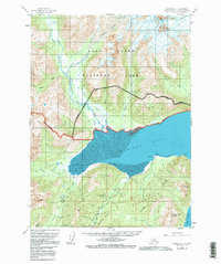
1958 Map of Iliamna D-1
USGS Topo · Published 1983About this map
Chinitna Bay and the northern reaches of Cook Inlet dominate the southern coastline of this survey, where the Tilted Peninsula Hills meet the water at landmarks like Seal Spit and Sea Otter Pt. The interior landscape is defined by massive ice fields and drainage systems, including the Umbrella Glacier and Tuxedni Glacier. A notable human addition to this wilderness is the Pipeline corridor that cuts across the northern terrain, traversing near Brown Mtn and Horn Mtn.
Find a feature on this map
39 named features on this map. Tap any name to fly to it.
Don’t see what you’re looking for? This feature index may not catch every label — zoom into the map to look around manually.
Map Details
Editions of this 1958 Iliamna D-1 Map
4 editions found

Other maps of this area

1944 · Kenai
USGS Topo · 1:250,000

1946 · Lake Clark
USGS Topo · 1:250,000

1949 · Iliamna C-1
USGS Topo · 1:63,360

1950 · Kenai
USGS Topo · 1:250,000

1951 · Lake Clark
USGS Topo · 1:250,000

1951 · Seldovia
USGS Topo · 1:250,000

1952 · Iliamna
USGS Topo · 1:250,000

1957 · Iliamna
USGS Topo · 1:250,000

1958 · Iliamna D-2
USGS Topo · 1:63,360

1958 · Iliamna C-2
USGS Topo · 1:63,360