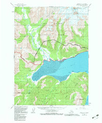
1958 Map of Iliamna D-1
USGS Topo · Published 1983About this map
Chinitna Bay dominates this coastal survey, where the glacial waters of the Kenai Peninsula meet the Cook Inlet. The map illustrates a complex transition between maritime environments and the high peaks of the Lake Clark National Park. Significant glacial features, including the Umbrella Glacier and its surrounding Crevasses, feed into a network of drainages like the Left Fork and Right Fork that flow toward Lake Clark. Along the southern coast, the Tilted Hills provide a backdrop to distinct coastal landmarks such as Seal Spit, Camp Pt, and Sea Otter Pt. The topography is defined by prominent summits like Mt Chinitna and South Chinitna Mountain, while low-lying areas are marked by the meandering Chinitna River and numerous small tributaries like Havenstrite Creek and Clearwater Creek.
Find a feature on this map
49 named features on this map. Tap any name to fly to it.
Don’t see what you’re looking for? This feature index may not catch every label — zoom into the map to look around manually.
Map Details
Editions of this 1958 Iliamna D-1 Map
4 editions found

Other maps of this area

1944 · Kenai
USGS Topo · 1:250,000

1946 · Lake Clark
USGS Topo · 1:250,000

1949 · Iliamna C-1
USGS Topo · 1:63,360

1950 · Kenai
USGS Topo · 1:250,000

1951 · Lake Clark
USGS Topo · 1:250,000

1951 · Seldovia
USGS Topo · 1:250,000

1952 · Iliamna
USGS Topo · 1:250,000

1957 · Iliamna
USGS Topo · 1:250,000

1958 · Iliamna D-2
USGS Topo · 1:63,360

1958 · Iliamna C-2
USGS Topo · 1:63,360