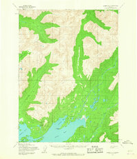
1954 Map of Iliamna D-3
USGS Topo · Published 1967About this map
Pile Bay Village and the small settlement of Pedro sit at the edge of the water in this mid-century survey conducted by the Army Map Service. The landscape is defined by the drainage of the Pile River as it flows south past Long Lake toward Pile Bay. A notable Native Trail is marked passing near Lonesome Bay, suggesting established routes through the interior before modern infrastructure arrived. The topography transitions from the coastal reaches of Pedro Bay and Iliamna Bay to the steep drainages of Canyon Cr and Knutson Creek. The presence of Big Chutes on the water and numerous small lakes like Dumbbell Lake indicates a complex system of waterways used for navigation and subsistence in this remote coastal region.
Find a feature on this map
15 named features on this map. Tap any name to fly to it.
Don’t see what you’re looking for? This feature index may not catch every label — zoom into the map to look around manually.
Map Details
Editions of this 1954 Iliamna D-3 Map
2 editions found
Other maps of this area

1946 · Lake Clark
USGS Topo · 1:250,000

1951 · Lake Clark
USGS Topo · 1:250,000

1952 · Iliamna
USGS Topo · 1:250,000

1954 · Lake Clark A-3
USGS Topo · 1:63,360

1954 · Iliamna D-3
USGS Topo · 1:63,360

1954 · Iliamna D-4
USGS Topo · 1:63,360

1954 · Iliamna C-3
USGS Topo · 1:63,360

1954 · Lake Clark A-4
USGS Topo · 1:63,360

1954 · Iliamna C-4
USGS Topo · 1:63,360

1957 · Iliamna
USGS Topo · 1:250,000