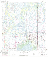
1958 Map of Immokalee NE
USGS Topo · Published 1983About this map
The boundary between Collier Co and Hendry Co runs vertically through this Florida landscape, where a patchwork of wetlands and agricultural tracts dominates the terrain. Established transit routes and drainage projects define the human footprint, most notably the Seaboard Coast Line railroad cutting across the southwestern corner. Revisions compiled from 1973 aerial photography highlight the evolution of land use in the mid-20th century, particularly the development of irrigation and containment systems like the Levee situated in the southeast. The survey reflects a transitional period for the region as dotted private land lines and unsurveyed sections meet increasingly structured farming and water management efforts.
Find a feature on this map
3 named features on this map. Tap any name to fly to it.
Don’t see what you’re looking for? This feature index may not catch every label — zoom into the map to look around manually.
Map Details
Editions of this 1958 Immokalee NE Map
4 editions found

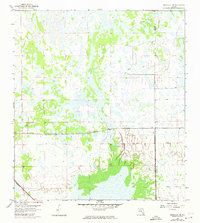
Other maps of this area

1956 · West Palm Beach
USGS Topo · 1:250,000

1957 · West Palm Beach
USGS Topo · 1:250,000

1958 · West Palm Beach
USGS Topo · 1:250,000

1958 · Felda SE
USGS Topo · 1:24,000

1958 · Immokalee
USGS Topo · 1:24,000

1958 · Felda
USGS Topo · 1:24,000

1958 · Sunniland
USGS Topo · 1:24,000

1958 · Immokalee NE
USGS Topo · 1:24,000

1958 · Immokalee SW
USGS Topo · 1:24,000

1971 · La Belle 4 SW
USGS Topo · 1:24,000