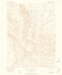
1955 Map of Independence Mountain
USGS Topo · Published 1956About this map
Independence Mountain dominates this landscape in Jackson County, where the high-altitude terrain is marked by a complex system of water management and ranching operations. The map reveals the intricate network of irrigation necessary for this high-country environment, including the Valley Creek Ditch and the Huntington (Abandoned) Ditch, alongside numerous small catchments like Threemile Reservoir and Campbell Reservoir. Evidence of early 20th-century life is found at the Simmons Ranch and Waldron Ranch, while the local education of the era is anchored by the Threemile Sch. The southern slopes are etched with numerous draws, such as Placer Draw and Lawrence Draw, leading toward an active Placer Mine. This mid-century survey captures a working landscape defined by the intersection of mountain geography and the hydraulic infrastructure required to sustain the cattle companies and settlers of the region.
Find a feature on this map
34 named features on this map. Tap any name to fly to it.
Don’t see what you’re looking for? This feature index may not catch every label — zoom into the map to look around manually.
Map Details
Editions of this 1955 Independence Mountain Map
5 editions found
Other maps of this area

1906 · Medicine Bow
USGS Topo · 1:125,000

1908 · Medicine Bow
USGS Topo · 1:125,000

1911 · Hahns Peak
USGS Topo · 1:125,000

1913 · Hahns Peak
USGS Topo · 1:125,000

1939 · Saratoga
USGS Topo · 1:125,000

1950 · Northgate
USGS Topo · 1:24,000

1952 · Northgate
USGS Topo · 1:24,000

1954 · Rawlins
USGS Topo · 1:250,000

1954 · Craig
USGS Topo · 1:250,000

1955 · Independence Mountain
USGS Topo · 1:24,000