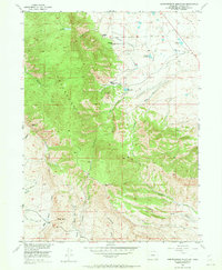
1955 Map of Independence Mountain
USGS Topo · Published 1973About this map
Independence Mountain dominates this mid-1950s survey of Jackson County, Colorado, where high-altitude ranching and mining define the landscape. The map details a complex network of water management, essential for high-country operations, including the Bighorn Cattle Company Ditch and the Huntington (Abandoned) Ditch. These irrigation features, alongside the Independence Ditch, supported local livestock interests and the homesteads at Simmons Ranch and Waldron Ranch.
Find a feature on this map
35 named features on this map. Tap any name to fly to it.
Don’t see what you’re looking for? This feature index may not catch every label — zoom into the map to look around manually.
Map Details
Editions of this 1955 Independence Mountain Map
5 editions found
Other maps of this area

1906 · Medicine Bow
USGS Topo · 1:125,000

1908 · Medicine Bow
USGS Topo · 1:125,000

1911 · Hahns Peak
USGS Topo · 1:125,000

1913 · Hahns Peak
USGS Topo · 1:125,000

1939 · Saratoga
USGS Topo · 1:125,000

1950 · Northgate
USGS Topo · 1:24,000

1952 · Northgate
USGS Topo · 1:24,000

1954 · Rawlins
USGS Topo · 1:250,000

1954 · Craig
USGS Topo · 1:250,000

1955 · Independence Mountain
USGS Topo · 1:24,000