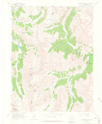
1960 Map of Independence Pass
USGS Topo · Published 1965About this map
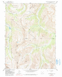
Independence Pass crowns this high-altitude landscape where the Continental Divide separates the White River and San Isabel national forests. The 1960 field survey captures a region defined by its mining heritage and complex water management systems, including the Lincoln Gulch Connection Canal and the Twin Lakes Reservoir and Canal Co Tunnel No 1. High-country settlements like Independence and Everett are situated along the Roaring Fork River and North Fork Lake Creek, while industrial remnants like the Ruby Mine and various Prospects dot the slopes of Red Mountain and Grizzly Peak. The map provides detailed topography of the granite summits including Ouray Peak and Garfield Peak, alongside modern recreational additions such as the Lost Man Campground and Portal Campground.
Find a feature on this map
51 named features on this map. Tap any name to fly to it.
Don’t see what you’re looking for? This feature index may not catch every label — zoom into the map to look around manually.
Map Details
Editions of this 1960 Independence Pass Map
5 editions found
Other maps of this area

1889 · Leadville
USGS Topo · 1:125,000

1891 · Leadville
USGS Topo · 1:125,000

1909 · Mount Jackson
USGS Topo · 1:125,000

1911 · Mount Jackson
USGS Topo · 1:125,000

1934 · Taylor Park
USGS Topo · 1:62,500

1935 · Mount Elbert
USGS Topo · 1:62,500

1937 · Taylor Park
USGS Topo · 1:62,500

1938 · Mount Elbert
USGS Topo · 1:62,500

1939 · Mount Elbert
USGS Topo · 1:62,500

1942 · Leadville
USGS Topo · 1:125,000