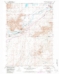
1951 Map of Independence Rock
USGS Topo · Published 1982About this map
Independence Rock stands as a massive landmark along the Sweetwater River, serving as a primary navigation point for early western travel. This mid-century survey captures the convergence of the Oregon Trail and the Pony Express Sta, highlighting the importance of the narrow passage at Devils Gate. The map notes an early Diversion Dam and several irrigation projects, including the Schounmaker Ditch (Aband), which illustrate the efforts to tame the arid basin. Near Sun Ranch, specialized markers designate an Historical Site where travelers carved their names and an Historical Marker (Grave) on the valley floor. High terrain features like Granite Mtn and the formations of Sentinel Rocks overlook the flat expanses of Beef Acres, defining the transition from the river bottom to the high Wyoming ridges.
Find a feature on this map
24 named features on this map. Tap any name to fly to it.
Don’t see what you’re looking for? This feature index may not catch every label — zoom into the map to look around manually.
Map Details
Editions of this 1951 Independence Rock Map
2 editions found
Other maps of this area

1951 · Savage Peak
USGS Topo · 1:24,000

1951 · Independence Rock
USGS Topo · 1:24,000

1951 · Fort Ridge
USGS Topo · 1:24,000

1953 · Buzzard Ranch
USGS Topo · 1:24,000

1953 · Spanish Mine
USGS Topo · 1:24,000

1955 · Casper
USGS Topo · 1:250,000

1958 · Casper
USGS Topo · 1:250,000

1959 · Sanford Ranch
USGS Topo · 1:24,000

1959 · Miller Spring
USGS Topo · 1:24,000
1959 · Beulah Belle Lake
USGS Topo · 1:24,000