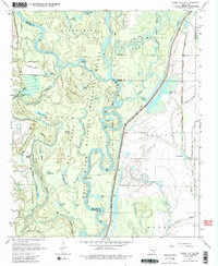
1967 Map of Indian Bay SE
USGS Topo · Published 1981About this map
The White River meanders through a complex delta landscape of oxbows and bottomlands in this mid-1960s survey. Much of the terrain is defined by the White River National Wildlife Refuge, where the river creates a dense network of secondary channels like Big Island Chute and White River Chute. These waterways isolate landforms such as Lone Willow Point and Hog Point, surrounded by a myriad of named water bodies including Cocklebur Lakes, Big White Lake, and Covington Lake. Small settlements and landmarks are clustered near the banks, notably Hortons Landing and the Chute Cem. To the south, the landscape transitions into a web of drainage features like Hurricane Bayou and Essex Bayou, illustrating the intricate hydrology of the Arkansas and Phillips county borderlands before further modern alteration.
Find a feature on this map
54 named features on this map. Tap any name to fly to it.
Don’t see what you’re looking for? This feature index may not catch every label — zoom into the map to look around manually.
Map Details
Editions of this 1967 Indian Bay SE Map
3 editions found
Other maps of this area

1930 · Mellwood
USGS Topo · 1:62,500

1939 · Modoc
USGS Topo · 1:62,500

1939 · Indian Bay
USGS Topo · 1:62,500

1939 · Henrico
USGS Topo · 1:62,500

1939 · Mellwood
USGS Topo · 1:62,500

1948 · Helena
USGS Topo · 1:250,000

1948 · Modoc
USGS Topo · 1:62,500

1950 · Helena
USGS Topo · 1:250,000

1954 · Mellwood
USGS Topo · 1:62,500

1954 · Indian Bay
USGS Topo · 1:62,500