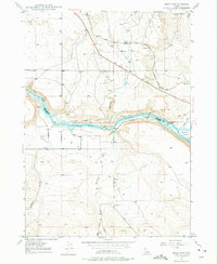
1947 Map of Indian Cove
USGS Topo · Published 1975About this map
The Old Oregon Trail cuts a diagonal path across the northern plateau of this Idaho landscape, running parallel to the Union Pacific railroad line. The terrain is defined by the deep gorge of the Snake River, which serves as the natural boundary between Elmore and Owyhee Counties. This mid-century survey illustrates a sparse ranching and transportation corridor, where water management is critical to the arid environment of Chalk Flat. The Indian Cove Bridge provides a vital crossing point near the mouth of Chalk Gulch, connecting the river bottomlands to the elevated ridges. Geologic landmarks such as Indian Point and Medbury Hill rise above the river valley, while smaller drainages like Browns Creek and Bennett Creek feed into the main waterway. Signs of local industry and infrastructure are present through a Gravel Pit and several Pumping Plants located along the riverbanks.
Find a feature on this map
21 named features on this map. Tap any name to fly to it.
Don’t see what you’re looking for? This feature index may not catch every label — zoom into the map to look around manually.
Map Details
Editions of this 1947 Indian Cove Map
4 editions found
Other maps of this area

1892 · Mountain Home
USGS Topo · 1:125,000

1892 · Camas Prairie
USGS Topo · 1:125,000

1893 · Mountain Home
USGS Topo · 1:125,000

1893 · Camas Prairie
USGS Topo · 1:125,000

1947 · Indian Cove
USGS Topo · 1:24,000

1947 · Hammett
USGS Topo · 1:24,000

1947 · Sand Dunes
USGS Topo · 1:24,000

1947 · Hot Spring
USGS Topo · 1:24,000

1948 · Sand Dunes
USGS Topo · 1:24,000

1948 · Hammett
USGS Topo · 1:24,000