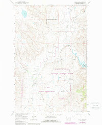
1965 Map of Indian Lake
USGS Topo · Published 1988About this map
Indian Lake sits at the heart of this central Montana landscape, where the high plains break into a complex network of drainages feeding into the Missouri River system. The mid-1960s terrain is characterized by the expansive Charles M Russell National Wildlife Refuge and the remote U L Bend Wilderness. These protected lands are defined by deep coulees like Valentine Coulee and Mickey Coulee, which carve through the high prairie toward the shoreline of Fort Peck Lake.
Find a feature on this map
25 named features on this map. Tap any name to fly to it.
Don’t see what you’re looking for? This feature index may not catch every label — zoom into the map to look around manually.
Map Details
Editions of this 1965 Indian Lake Map
2 editions found
Other maps of this area

1954 · Jordan
USGS Topo · 1:250,000

1956 · Jordan
USGS Topo · 1:250,000

1958 · Jordan
USGS Topo · 1:250,000

1964 · Jordan
USGS Topo · 1:250,000

1965 · Lost Creek
USGS Topo · 1:24,000

1965 · Sun Prairie
USGS Topo · 1:24,000

1965 · Herman Point
USGS Topo · 1:24,000

1965 · Locke Ranch
USGS Topo · 1:24,000
1965 · Mickey Butte
USGS Topo · 1:24,000
1965 · Stratton Reservoir
USGS Topo · 1:24,000