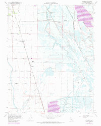
1960 Map of Ingomar
USGS Topo · Published 1972About this map
The town of Gustine and the settlement at Ingomar anchor this Central Valley landscape, dominated by a complex network of water management and seasonal wetlands. The map illustrates a distinctive pattern of early 1970s land use, where the agricultural grid meets the marshy terrain of the Duck Ponds and the San Luis Holding Reservoir. A notable concentration of private sporting clubs, including the Gustine Gun Club, Oakland Gun Club, and Salinas Gun Club, are situated along the Old Santa Fe Grade and the various sloughs and ditches that feed the basin.
Find a feature on this map
43 named features on this map. Tap any name to fly to it.
Don’t see what you’re looking for? This feature index may not catch every label — zoom into the map to look around manually.
Map Details
Editions of this 1960 Ingomar Map
2 editions found
Other maps of this area

1917 · Newman
USGS Topo · 1:31,680

1918 · Stevinson
USGS Topo · 1:31,680

1918 · Gustine
USGS Topo · 1:31,680

1919 · Orestimba
USGS Topo · 1:62,500

1919 · San Luis Ranch
USGS Topo · 1:31,680

1919 · Ingomar
USGS Topo · 1:31,680

1920 · Pacheco Pass
USGS Topo · 1:62,500

1921 · Volta
USGS Topo · 1:31,680

1921 · Los Banos
USGS Topo · 1:31,680

1922 · San Luis Creek
USGS Topo · 1:31,680