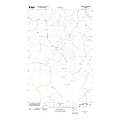
2011 Map of Inkster Lake
USGS Topo · Published 2011About this map
Egypt stands as a focal point in this portion of Lincoln County, where the landscape is defined by the winding drainages of Pitney Creek and Indian Creek. The terrain transitions from the low-lying Sand Flat in the northeast to the shadowed depths of Green Canyon. Central to the local community is the North Star Grange, situated just north of Inkster Lake. This rural network is interconnected by a grid of named local roads, such as Porcupine Bay Rd N and Pankey Rd E, which reflect the area's agricultural and ranching heritage. The presence of the Spokane River Arm at the northeastern corner suggests the region's connection to larger Pacific Northwest water systems, while the interior is marked by intermittent flows like Alder Creek that carve through the high plateau geography.
Find a feature on this map
25 named features on this map. Tap any name to fly to it.
Don’t see what you’re looking for? This feature index may not catch every label — zoom into the map to look around manually.
Map Details
Editions of this 2011 Inkster Lake Map
This is the sole edition of this map. No revisions or reprints were ever made.
Other maps of this area

1948 · Lincoln
USGS Topo · 1:62,500

1948 · Turtle Lake
USGS Topo · 1:62,500

1950 · Lincoln
USGS Topo · 1:62,500

1950 · Turtle Lake
USGS Topo · 1:62,500

1953 · Ritzville
USGS Topo · 1:250,000

1959 · Ritzville
USGS Topo · 1:250,000

1965 · Ritzville
USGS Topo · 1:250,000
1969 · Mondovi
USGS Topo · 1:24,000

1969 · Rocklyn
USGS Topo · 1:24,000
1969 · Davenport
USGS Topo · 1:24,000