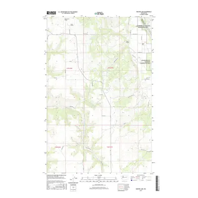
2017 Map of Inkster Lake
USGS Topo · Published 2017About this map
Lake Roosevelt National Recreation Area occupies the northeastern corner of this Lincoln County landscape, where the Spokane River Arm meets the rugged breaks of the plateau. The terrain is defined by dramatic drainage systems, including the steep-walled Bockemuehl Canyon and Snook Canyon in the north, and the meandering Indian Cr to the south. Small water bodies like Inkster Lake sit amidst a network of rural roads that follow the section lines and natural contours of the land. The presence of Sand Flat and Green Canyon suggests a topography shaped by both ancient glacial outflows and the persistent erosion of creeks such as Pitney Cr and Alder Cr. This document provides a clear view of the modern land management and rural infrastructure in the Egypt region during the early 21st century.
Find a feature on this map
40 named features on this map. Tap any name to fly to it.
Don’t see what you’re looking for? This feature index may not catch every label — zoom into the map to look around manually.
Map Details
Editions of this 2017 Inkster Lake Map
This is the sole edition of this map. No revisions or reprints were ever made.
Other maps of this area

1948 · Lincoln
USGS Topo · 1:62,500

1948 · Turtle Lake
USGS Topo · 1:62,500

1950 · Lincoln
USGS Topo · 1:62,500

1950 · Turtle Lake
USGS Topo · 1:62,500

1953 · Ritzville
USGS Topo · 1:250,000

1959 · Ritzville
USGS Topo · 1:250,000

1965 · Ritzville
USGS Topo · 1:250,000
1969 · Mondovi
USGS Topo · 1:24,000

1969 · Rocklyn
USGS Topo · 1:24,000
1969 · Davenport
USGS Topo · 1:24,000