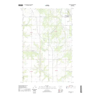
2020 Map of Inkster Lake
USGS Topo · Published 2020About this map
Lake Roosevelt National Recreation Area occupies the northeast corner of this landscape, where the plateau meets the Columbia River drainage at the Lincoln and Stevens County line. The topography is defined by a series of dramatic drainages including Snook Canyon and Green Canyon, which cut through the high ground toward the river valley. The agricultural and ranching character of the region is evident in the network of rural routes such as Mule Ranch Rd, Egypt Loop Rd, and Curliss Ranch Dr N.
Find a feature on this map
35 named features on this map. Tap any name to fly to it.
Don’t see what you’re looking for? This feature index may not catch every label — zoom into the map to look around manually.
Map Details
Editions of this 2020 Inkster Lake Map
This is the sole edition of this map. No revisions or reprints were ever made.
Other maps of this area

1948 · Lincoln
USGS Topo · 1:62,500

1948 · Turtle Lake
USGS Topo · 1:62,500

1950 · Lincoln
USGS Topo · 1:62,500

1950 · Turtle Lake
USGS Topo · 1:62,500

1953 · Ritzville
USGS Topo · 1:250,000

1959 · Ritzville
USGS Topo · 1:250,000

1965 · Ritzville
USGS Topo · 1:250,000
1969 · Mondovi
USGS Topo · 1:24,000

1969 · Rocklyn
USGS Topo · 1:24,000
1969 · Davenport
USGS Topo · 1:24,000