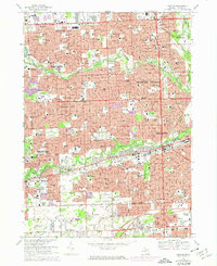
1968 Map of Inkster
USGS Topo · Published 1974About this map
The settlement of Eloise and its sprawling institutional grounds anchor the central landscape of this western Wayne County survey. At this time, the area is undergoing rapid post-war suburbanization, with dense residential grids filling the spaces between Livonia, Westland, and Garden City. The Middle Rouge River and Lower Rouge River provide natural greenbelts through the expanding urban environment, hosting the Warren Valley Golf Course and Dearborn Hills Golf Club. Local history and genealogy interest is concentrated in several large memorial grounds, including Cadillac Memorial Gardens West Cem and Westlawn Cemetery. The infrastructure of the era is evident in the burgeoning road network, where Telegraph Road and the Detroit Industrial Freeway facilitate regional transit alongside the Norfolk and Western rail lines.
Find a feature on this map
161 named features on this map. Tap any name to fly to it.
Don’t see what you’re looking for? This feature index may not catch every label — zoom into the map to look around manually.
Map Details
Editions of this 1968 Inkster Map
Other maps of this area

1905 · Wayne
USGS Topo · 1:62,500

1905 · Detroit
USGS Topo · 1:62,500

1906 · Wyandotte
USGS Topo · 1:62,500

1906 · Romulus
USGS Topo · 1:62,500

1912 · Wyandotte
USGS Topo · 1:62,500

1912 · Wayne
USGS Topo · 1:62,500

1918 · Detroit
USGS Topo · 1:62,500

1924 · Detroit
USGS Topo · 1:62,500

1928 · Romulus
USGS Topo · 1:62,500

1929 · Wyandotte
USGS Topo · 1:62,500