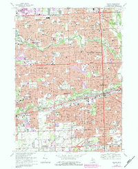
1968 Map of Inkster
USGS Topo · Published 1984About this map
The Middle Rouge River and Lower Rouge River carve green corridors through the dense suburban expansion of western Wayne County, Michigan. This mid-century survey illustrates the rapid maturation of the Detroit metropolitan area, where residential subdivisions and neighborhood parks like Clements Circle Park and Rosedale Gardens Park have largely filled the space between established centers. The presence of the County Hospital and the historic Eloise settlement near the Conrail line reflects the long-standing social infrastructure of the region. Local heritage is deeply etched into the landscape through a network of parochial institutions, including St Robert Bellarmine Sch and St Michael Sch, alongside large commemorative sites such as Cadillac Memorial Gardens West Cem. The map serves as a detailed record of the postwar industrial and residential bloom that defined communities from Livonia to Taylor.
Find a feature on this map
85 named features on this map. Tap any name to fly to it.
Don’t see what you’re looking for? This feature index may not catch every label — zoom into the map to look around manually.
Map Details
Editions of this 1968 Inkster Map
Other maps of this area

1905 · Wayne
USGS Topo · 1:62,500

1905 · Detroit
USGS Topo · 1:62,500

1906 · Wyandotte
USGS Topo · 1:62,500

1906 · Romulus
USGS Topo · 1:62,500

1912 · Wyandotte
USGS Topo · 1:62,500

1912 · Wayne
USGS Topo · 1:62,500

1918 · Detroit
USGS Topo · 1:62,500

1924 · Detroit
USGS Topo · 1:62,500

1928 · Romulus
USGS Topo · 1:62,500

1929 · Wyandotte
USGS Topo · 1:62,500