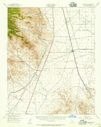
1943 Map of Inyokern
USGS Topo · Published 1956About this map
Indian Wells Valley is defined by the sharp transition between the high peaks of the Sierra Nevada and the arid lowlands where early twentieth-century infrastructure meets the desert floor. The Los Angeles Aqueduct cuts a stark line along the base of the mountains, following the contours of the range near Owens Peak and Morris Peak. This 1943 survey, published during the height of mid-century expansion, documents the intersection of essential transport and utility corridors, including the Southern Pacific railroad and a significant U S Naval Reservation boundary.
Find a feature on this map
33 named features on this map. Tap any name to fly to it.
Don’t see what you’re looking for? This feature index may not catch every label — zoom into the map to look around manually.
Map Details
Editions of this 1943 Inyokern Map
4 editions found
Other maps of this area

1903 · Randsburg
USGS Topo · 1:62,500

1906 · Kernville
USGS Topo · 1:125,000

1908 · Kernville
USGS Topo · 1:125,000

1911 · Randsburg
USGS Topo · 1:62,500

1912 · Randsburg
USGS Topo · 1:62,500

1915 · Searles Lake
USGS Topo · 1:250,000

1915 · Mojave
USGS Topo · 1:125,000

1943 · Inyokern
USGS Topo · 1:62,500

1943 · Cross Mountain
USGS Topo · 1:62,500

1943 · Saltdale
USGS Topo · 1:62,500